El Hormiguero, Mexico.
Stone Gods at the End of the Jungle, Past the Last Paved Road.
Looking for concrete details and tips? Go straight to the Practical Information section.
This article is part of a bigger trip through the seldom visited Mayan archeological sites of the southern Yucatan peninsula. See all articles here.A one-day itinerary to see the best Rio Bec Maya cities is also here.
I had just finished visiting the intimate site of Chicanná and, walking back to my car under a sun that was starting to feel hostile, was pondering my options. I had decided to spend one day in the Rio Bec area, this region of southeastern Campeche home to Maya sites notable for their specific architecture, and I wanted to visit at least four of them.
El Hormiguero was the furthest and hardest to reach, and any rational thinking should have left it for the end of the day, if time allowed. Yet there was something about this site, based on the photos I had seen online, that made me want to head there. I knew it didn’t make sense. The trip out and back plus the visit meant I would only get to eat lunch super late, and may not have the time to see another, closer site, Xpujil, as I had to drive to Calakmul the same day, and get into the Biosphere Reserve before nightfall.
Still, I decided to chance it, turned on the car (and, most importantly, the A/C), and went on my way.
If Becán and Chicanná had been easy to get to from Xpujil, where I had been staying - they both sat along federal Highway 186, a well-maintained major road - El Hormiguero would be a little bit different. Turning right in Xpujil, I first got to see the real center of the little town, away from route 186 with its colorful stalls and busy customers.
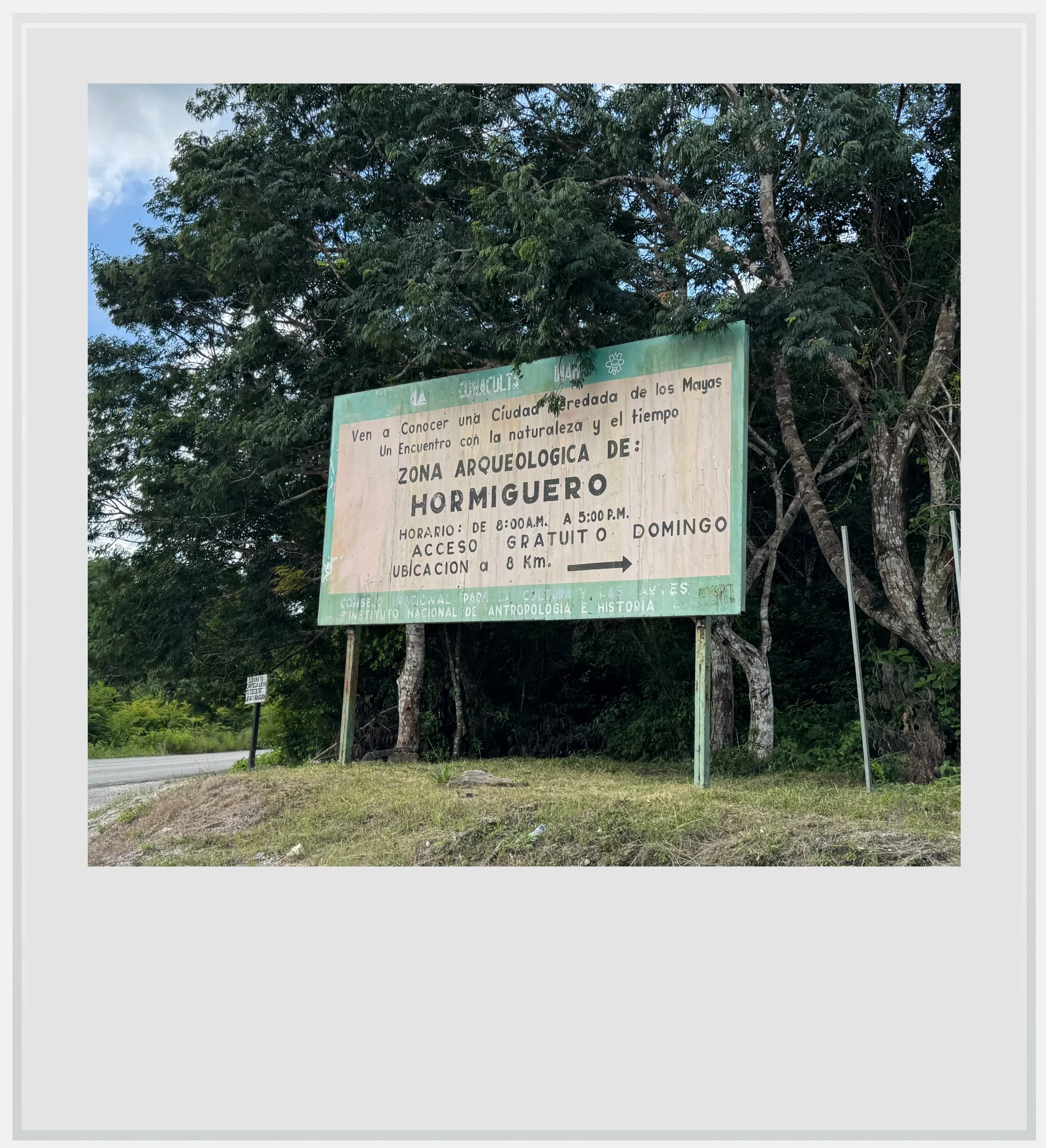
Access sign to El Hormiguero from route 269, south of Xpujil, Mexico. Note the site is free every day, not just on Sunday, as of publishing date.
Route 269, going south, felt like a mini version of the federal highway I had just left behind. It was only after making another right, encouraged by an unusually large and colorful sign extolling the Hormiguero archeological zone, and passing the small settlement of Eugenio Echeverría Castellot that I realized the rest of the trip would be no picnic.
It stood to reason that a road whose sole purpose was to give access to a seldom-visited ancient Maya settlement wouldn’t be the #1 priority for the Campeche Department of Transportation, but this one took the cake. An urban legend explains that access to El Hormiguero is free because no one from the village would want to drive that road twice a day. I could believe this as I slowly drove through every shape of pothole imaginable, on a road that was getting narrower as I made progress, terminating in a narrow, unpaved path.
How many starving jaguars were watching our every move, thinking about lunch?
Instead of making me want to turn around, it strengthened my resolve to see what lay at the end of it - this bit of exploring was turning into a true expedition, and I can’t say I minded.
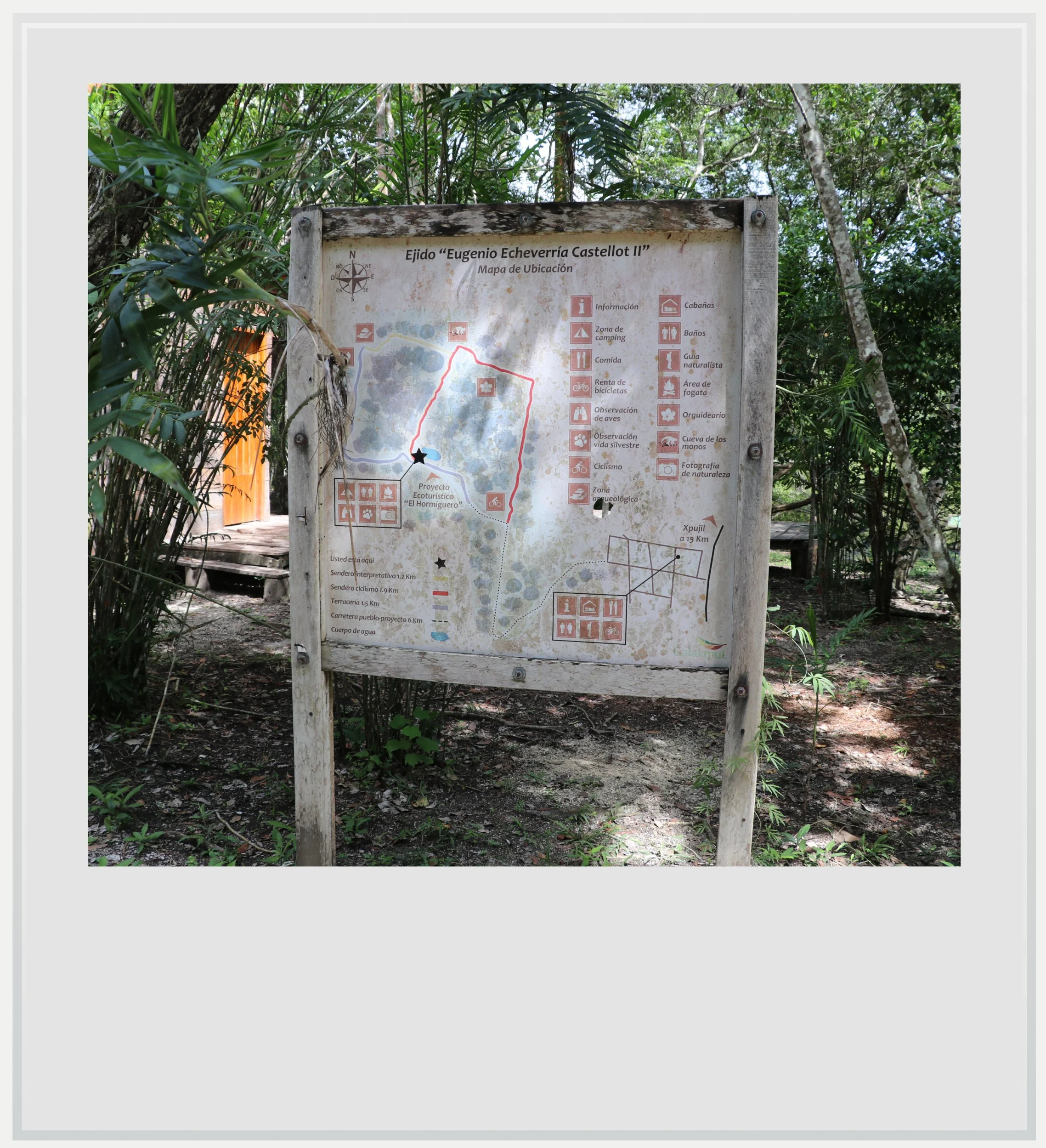
After a while, I reached a small clearing dotted with a few wooden buildings by a small lake, where an official-looking sign labeled the area an Ecoproject. Indeed, it looked like a great place to set up camp, although the mention of a spot to observe wildlife, using the paw print of a jaguar as an icon, made my blood run cold.
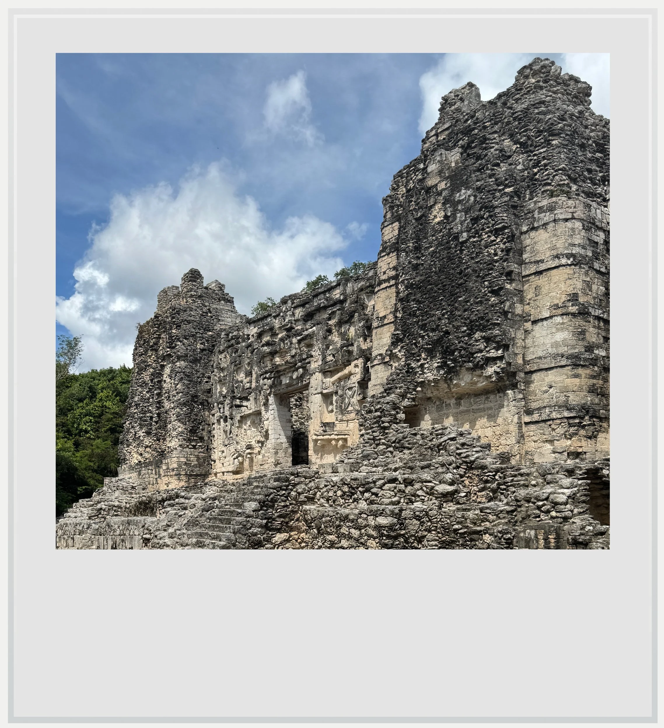
Structure 2 seen from the side, at El Hormiguero.
The map made it seem like the Maya ruins weren’t far, and because there was space to park along the path, I decided to stop there, and walk the ten or so minutes to the gate, jaguar paw prints be damned.
It turned out to be a wise move. Not only was the walk in the jungle fairly nice - and thankfully devoid of any harmful encounter with wildlife, if you discount playful spider monkeys - but the last few meters of the road leading to the small car park for the ruins would have been hard to ride in a regular rental car, given the slope and the unevenness of the terrain. A 4x4 vehicle would have had no issue, but I was glad I didn’t drive all the way up there in my little Nissan, only to have to turn back.
By the time I got into the parking lot, I was glad to see human begins working on improving the archeological zone’s access (a constant in the region, given the federal government’s investment in upgrading the tourist infrastructure alongside the Maya train). I hadn’t seen or heard another person ever since I had driven past the little hamlet on the side of the road half an hour earlier.
This gave me a false sense of safety. In fact, counting the three visitors and the four employees on site, we were probably the only 8 people within miles of deep jungle (how many starving jaguars were watching our every move, thinking about lunch? I’ll never know). After confirming the access was indeed free, I started walking towards the main site.

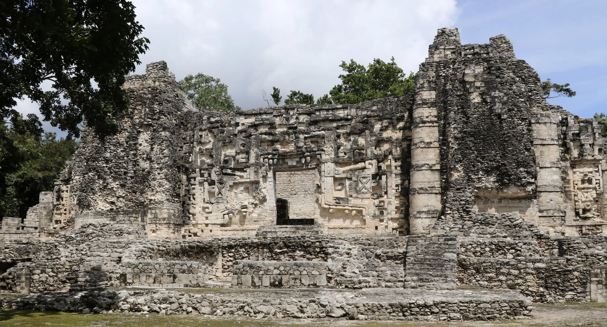
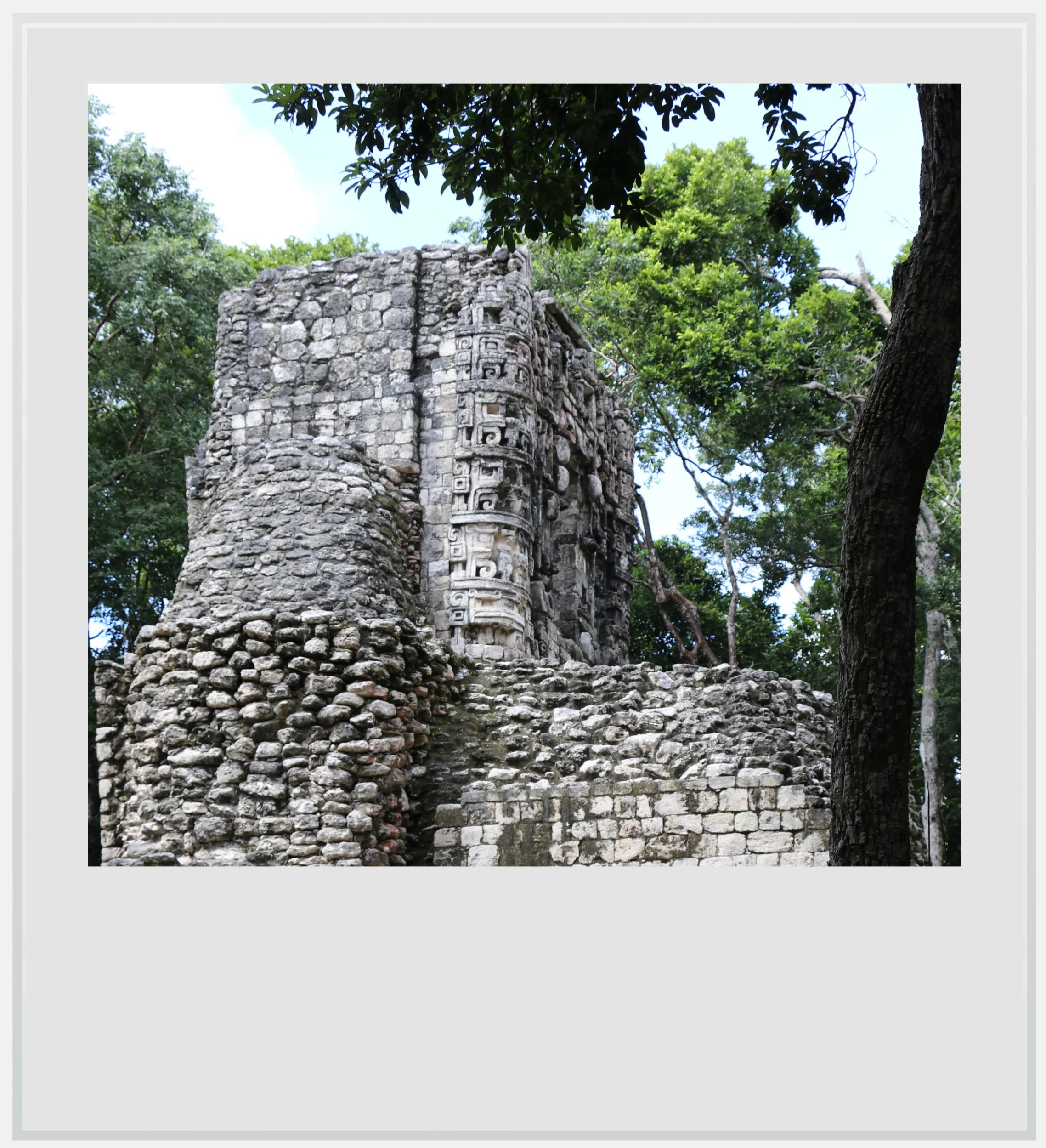
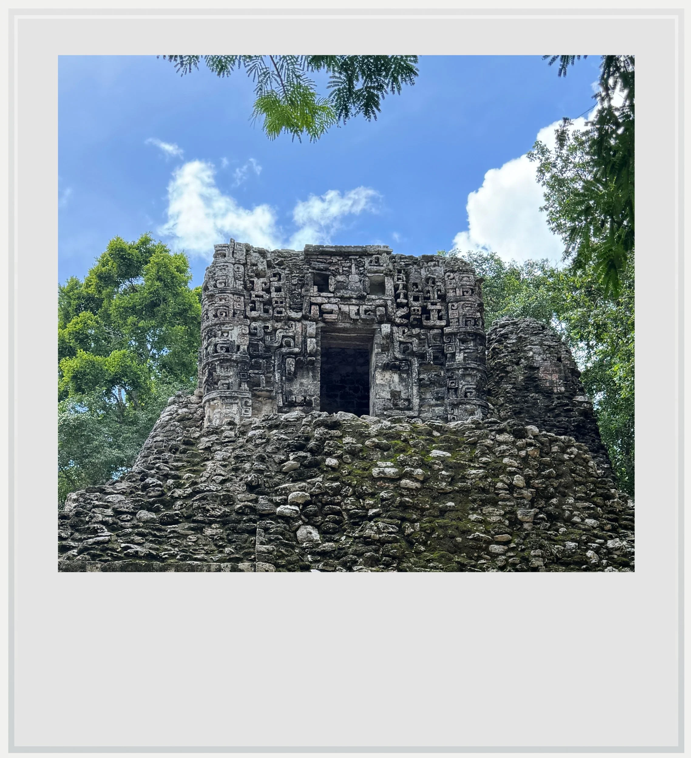
Structure 2 at El Hormiguero, with its two Rio Bec towers and its Chenes door.
Records indicate the site of El Hormiguero (meaning “ant hill” in Spanish, for a water source nearby) was inhabited early on, from 350 AD, but most of the buildings on the site date from the Late Classic Maya period, from the seventh to the ninth century, which marked the peak of the Maya civilization in the region. The settlement was rediscovered in 1933 during a expedition to find Sapodilla trees, whose sap was used to create chewing gum. While eighty-four structures were identified on the site, only a few major ones have been excavated so far. The main one, upon which I walked first, was one of the most awe-inspiring buildings in the whole region.
Structure II, in the South building cluster, was a fantastic example of Maya architecture of the period, mixing two somewhat-related style, Rio Bec and Chenes. Rio Bec, the name of the region (Rio Bec means Bec River in Spanish), is also the modern name of a Maya site further west, that gave its name to the regional style, consisting of replicating a miniature version of the Peten style symbolized by Tikal, in Guatemala, with tall towers built on top of classical Maya temples. In the Rio Bec style, these towers, usually three evenly distributed between left, front and right of the structure, are only decorative. Their extremely steep stairs aren’t usable, and the temples at the top are devoid of any religious purpose. It seemed like the Rio Bec style was aimed to inspire awe without reaching the heights of Tikal. Great examples of Rio Bec style can also be seen at Becán, further north. Here in El Hormiguero, Structure II only possessed two towers, separated by a Chenes-style door.
I slowly drove through every shape of pothole imaginable.
Also seen in nearby Chicanná, and developed further to the north of the state of Campeche, the Chenes style derives its name from the area where it was first discovered, in a region where towns end with the suffix “-chen”, meaning “well” in Yucatec Maya. The Chenes style is heavy in carved mosaic facades but is most famous for featuring massive doors framed with monster masks. These are thought to portray a Maya god, where the door stands for the mouth of its distorted face, and represents a symbolic entrance into the spiritual world where these gods lived. Here, the door on Structure II is meant to embody Itzamná, the supreme creator god and patron of the ruling elite in Maya mythology.
In Chicanná, earlier in the day, I was able to see a great example of Chenes style on Structure II, but that building was constructed in a more faithful Chenes style as a more compact edifice, without the classic Rio Bec towers. Here in El Hormiguero, Building 2 incorporated the grandeur of the Rio Bec towers with the intricacy and splendor of a Chenes door, and the result was quietly compelling.
A side view of Structure 5 in El Hormiguero, with Chenes-style temple at the top.
Even though Building 2 wasn’t as well preserved as other structures in the region, it was hard not to be impressed by its overall presence. I was once again reminded of the extraordinary talent the Maya architects and sculptors must have possessed to create such incredible facades more than a thousand years ago.
Another notable building on the site is Structure V, a platform supporting another beautiful one-story Chenes-style construction, probably a temple.
While rather compact, El Hormiguero is rich in other partially excavated buildings, and it can take a few minutes to go from one of the three clusters on the map, South, Central and North groups.

What stayed with me.
Although it lacked the massive grandeur of Becán, El Hormiguero was my favorite site in the Bec River region, for its remote jungle setting and the historical testimony of its main building, blending Maya architectural styles with brio.
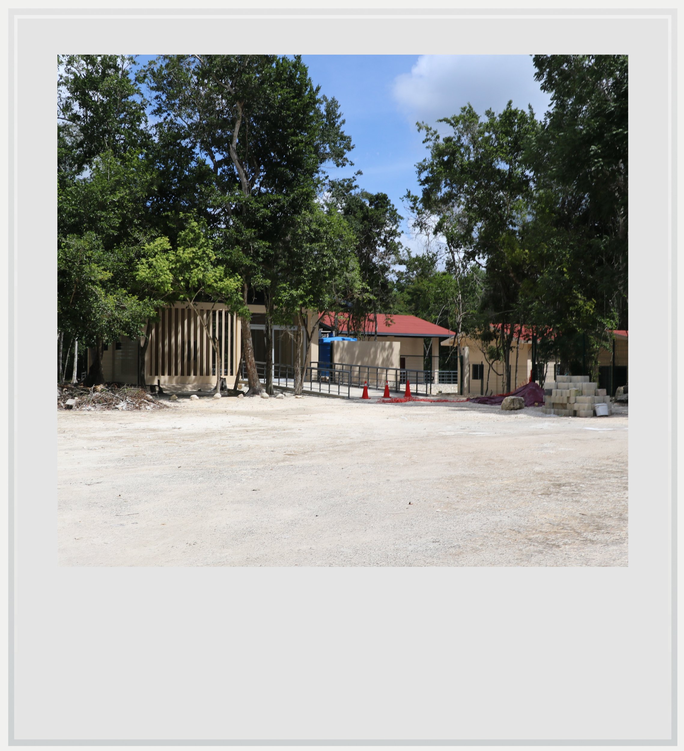
Work happening at the future Visitor Center in El Hormiguero.
Practical information
(Everything you could possibly want to know about El Hormiguero - updated January 2026)
In a nutshell
El Hormiguero, a medium-sized Maya site in the Rio Bec area of southeastern Campeche, was my favorite site in the region. It is best visited alongside other sites, in a one-day or two-day itinerary that should include nearby sites like Becán and Chicanná.
At the end of a narrow road that can only be charitably described as very poorly maintained, the site is stunning not only for how it intricately blends the Rio Bec and Chenes architectural styles, but also for its setting deep in the Maya jungle.
Getting to El Hormiguero
How to get to El Hormiguero from the United States: El Hormiguero, in southeastern Campeche, isn’t easy to reach from the US. The closest airport to El Hormiguero is Chetumal (CTM), which has no direct flights to the US, making a connection in Mexico City (MEX) indispensable. El Hormiguero lies about 2h15 west of Chetumal airport, on Federal Highway 186, a well-maintained road with little traffic. It is approximately 13 miles (35 minutes) south of Xpujil, which will likely be the base for exploring the Rio Bec Maya sites.
The Ecopark sign on the road to El Hormiguero. I parked nearby and walked the last ten minutes of the way.
Another option could be to fly into Tulum (TQO), if planning a trip spanning more of the Yucatán peninsula, as US and Canadian airlines fly non-stop to the new Tulum airport, but travel time from TQO to El Hormiguero is over 4.5 hours.
Car rental is your best bet to visit the region, and the Chetumal airport has several local and international options, which were fairly priced at the time of my visit (provided you don’t fall for the pushy additional insurance coverage every single rental agent is incentivized to sell you). While ADO and Suchaa, a colectivo service, stop in nearby Xpujil, this isn’t close to the ruins, and you’ll need a long taxi ride to get there. It is unlikely to be a serious option, however, given the state of the road, and you’d have to pay the taxi to wait for you and bring you back. Renting a car makes the most sense from a planning and cost perspective, especially as part of a broader trip to nearby sites.
How to get to El Hormiguero from Mexico City: while it is possible to take a bus from the TAPO terminal in the capital all the way to Xpujil, a few miles from the El Hormiguero ruins, it isn’t recommended. The trip lasts more than 18 hours, in a first class bus that’s comfortable enough for a 3 to 4-hour ride, but we’re talking about a trip that’s more than 4 times longer. The walk-up fare is MXN 1,822 (about USD100 at time of writing) which isn’t super competitive with flying.
The best way to reach El Hormiguero is indeed to fly into Chetumal airport (CTM), from Mexico City’s main airport (MEX) or its secondary airport (NLU). Aeromexico, VivaAerobus and Volaris operate once a day between MEX and CTM while Mexicana and Viva fly several days a week from NLU to CTM, with base prices starting around USD75. Car rentals are widely available at Chetumal airport, from a variety of Mexican and international companies. El Hormiguero is about 2h15 west of the airport, along Federal Highway 186, a well-maintained, straight-through-the-jungle two-lane road.
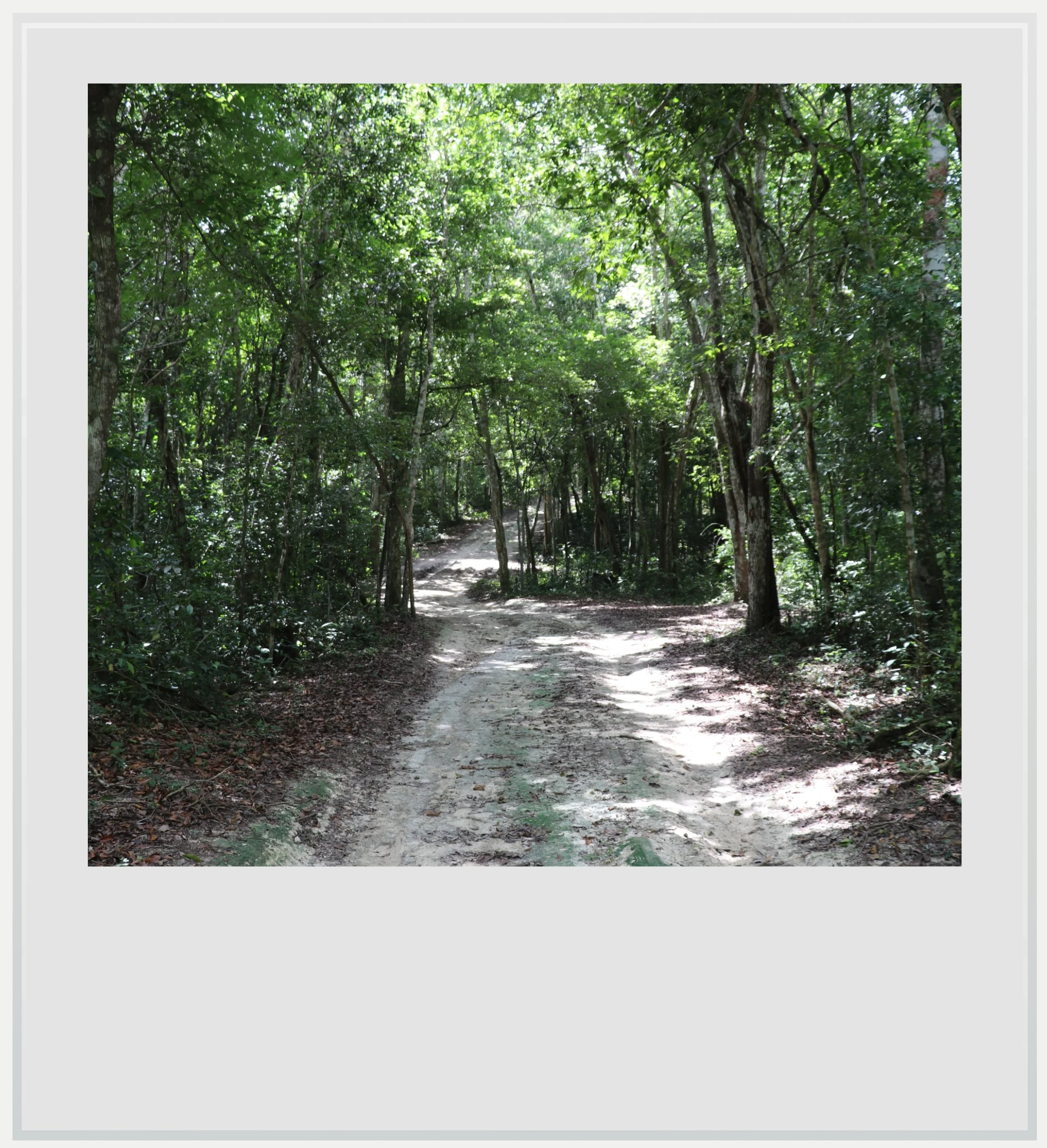
The last mile of the road to El Hormiguero, which I walked.
When to go to El Hormiguero
The best months weather-wise to enjoy El Hormiguero are during the dry season, between November and April, with January and February the (relatively) coolest months. This is also peak season but, given its location, the site is never crowded.
I went to El Hormiguero in October, which is low season as the combination of possible afternoon showers and intense heat can turn off travelers. I loved it for the lack of crowds, and the slightly overcast weather which made the heat tolerable. I was one of only four visitors during my whole time at El Hormiguero, and almost had the site to myself, which was incredible.
Aim to go to the site early (they open at 8am) or late (around 3pm, to give you two hours before they close), to avoid the hottest hours of the day. That being said, El Hormiguero, like most other sites around Xpujil, lies in the middle of the jungle, and most of your steps will be in the shade, making a visit around midday tolerable.
How much does it cost to visit El Hormiguero
Entrance is currently free, but it may not stay that way for long as the Mexican government is funding improvements on the site, including bathrooms and a small visitor center which will, no doubt, include a ticket office (this, for the record, is a good thing to help preserve this amazing place).
The Chenes-style temple at the top of building 5 in El Hormiguero.
How long should I plan to visit El Hormiguero
Plan to spend 30 to 45 minutes at the site, understanding only a few of the eighty-four noted structures have been already excavated.
Given the site’s isolation, no services are available - and note that I wasn’t able to drive all the way to the site with my small rental. Vehicles with higher clearance should be fine, but I had to walk 10 minutes by foot to the gate.
What are the opening times of El Hormiguero
The site is open every day from 8am to 5pm. There is currently no INAH presence on site, and the only people you will likely see are workers building the small visitor facilities.
Safety in El Hormiguero
The Yucatán peninsula is one of the safest areas in Mexico, and Campeche is one of the few Mexican states with no travel advisory: it is labeled a level 1 “Exercise Normal Precautions” state, just like anywhere in the US. As such, there is no need to worry any more than if you were taking a California to Vegas roadtrip.
On a slightly different note, and because the site is located in the Maya lowlands, deep in the jungle, snake sightings are frequent. Be aware of where you put your feet at all times, but especially close to stones and on the narrow dirt paths linking the buildings.
Food & lodging near El Hormiguero
El Hormiguero is located 35 minutes south of the town of Xpujil, which will most likely be your base: it has hotels, restaurants, gas stations and yes, three OXXOs, and at least one of which is open 24/7.
Hotels
I stayed at the highly-rated Hotel Casa Las Lolas, on the outskirts of town. The hotel is actually made up of about 10 self-contained casitas, well-appointed, with kitchenette, good wifi and self-parking. I would definitely stay there again. Prices about $100 a night.
Locals recommended the Hotel Villa Calakmul as a more affordable option in town. It is fairly basic, but seemed clean and safe and was away from the main road so traffic noise isn’t an issue.
Restaurants
My favorite for breakfast: Antojitos Doña Evita. Good food, great service. It’s basic but super clean and affordable. Totally recommended
A good treat for dinner: Sazón Veracruz. A large menu and a choice of terrace or indoor seating at a very reasonable price, as well as excellent Google reviews make this a safe bet. I had the meat, mushroom and cheese tacos which were decent, but price to quantity ratio was incredible.
Keep in mind these travel tips
The Yucatán peninsula is one of the safest regions in Mexico, and its main roads are well maintained. This isn’t enough to forget the #1 driving advice in Mexico: do not drive at night. Driving at night, on poorly lit roads means you won’t see the motorcycles without lights, the potholes and the ubiquitous topes, these notoriously hard speed bumps that spring out of nowhere. You may encounter wildlife or, more prosaically street dogs crossing right in front of you. Plan your itinerary to be at your next destination before night fall. It’s important.
No matter what the season, there will be bugs in Yucatan. While you may only see the gigantic Tarántula Yucateca spider on the roads leading to Calakmul, you’ll find mosquitoes pretty much everywhere, and especially in the shaded forests surrounding the Maya ruins. Be ready with repellent at any time of the day. It’s also a good idea to wear clothes that cover your limbs (pants, high socks, long sleeve t-shirts) while you’re in the jungle. Mosquito-borne diseases are fairly uncommon in the state of Campeche, but not unheard of.
SPF will be your best friend. The UV index may be low in the morning and evening, but during the day, it gets pretty high.
Do not forget to hydrate. While OXXOs aren’t as ubiquitous in this rural region than in other ones, you’ll find plenty of abarrotes, these tiny stores selling cold water and sodas along the way. Make sure you always have water handy and drink to make the heat more bearable.
Cell service is spotty at best in southeastern Campeche, with Telcel the only provider with decent service in some places. If you’re roaming, check that you can roam on Telcel, or investigate a Mexican eSIM that uses this network. If not, think about downloading maps for offline use, it may prove very useful.
Every photo’s legend will appear if you hover over it (on a computer) or click on it (on a smartphone).
All photos are mine and copyrighted.