Four Days in Ushuaia and the Tierra del Fuego National Park, Argentina.
This is the first part of a longer trip to Argentina. After Ushuaia, we flew to El Calafate and spent four days hiking in El Chaltén. You can read about it here. Our full 3-week tour and how its itinerary came together can be found here.
Seconds before landing at Ushuaia airport, the heavy cloud cover that had been blocking our view for the past three hours or so opened up and we could finally see the snowy mountains surrounding the Beagle channel.
Ushuaia, one of the most remote towns on the planet, claims to be the world’s southernmost city. The title is actually contested by Puerto Williams, on the Chilean side of the Beagle Channel, and therefore further south than Ushuaia. Ushuaia locals are be pretty quick to remind you Puerto Williams is a “settlement” and not a real city, but the matter is far from settled.
In any case, getting to Ushuaia really feels like getting to the end of the world. The first thing you notice is how the light hits differently. Even in the summer, the sun doesn’t quite feel like it’s giving as much light as it does in lower latitudes, and at its zenith, you may be forgiven to feel you’re in Western Europe in the dead of winter.
The beautiful, snow-capped mountains surrounding Ushuaia reminded me of Alaska, and upon landing, I wondered out loud if we hadn’t been rerouted to Juneau. The light, the greenery, the scenery all made me think of the Alaskan capital and its surroundings.

The view from the Valle Carbajal viewpoint on the RN3 road north of Ushuaia.
We were in Ushuaia for four days, with the idea of spending three of them in the Tierra del Fuego National Park. As such, we used our short, first day to be acquainted with the town and its region.
I had visited Ushuaia alone two years ago -almost to the day- as part of a bigger Argentina trip. This time, in March 2025, I was with family, but I already knew which spots we would hit – either because I had been to them before and wanted to share them with the new travelers, or because I had missed them last time and really wanted to find a way to get to them this year.
We were treated to an almost 360-degree view over southern Patagonia.
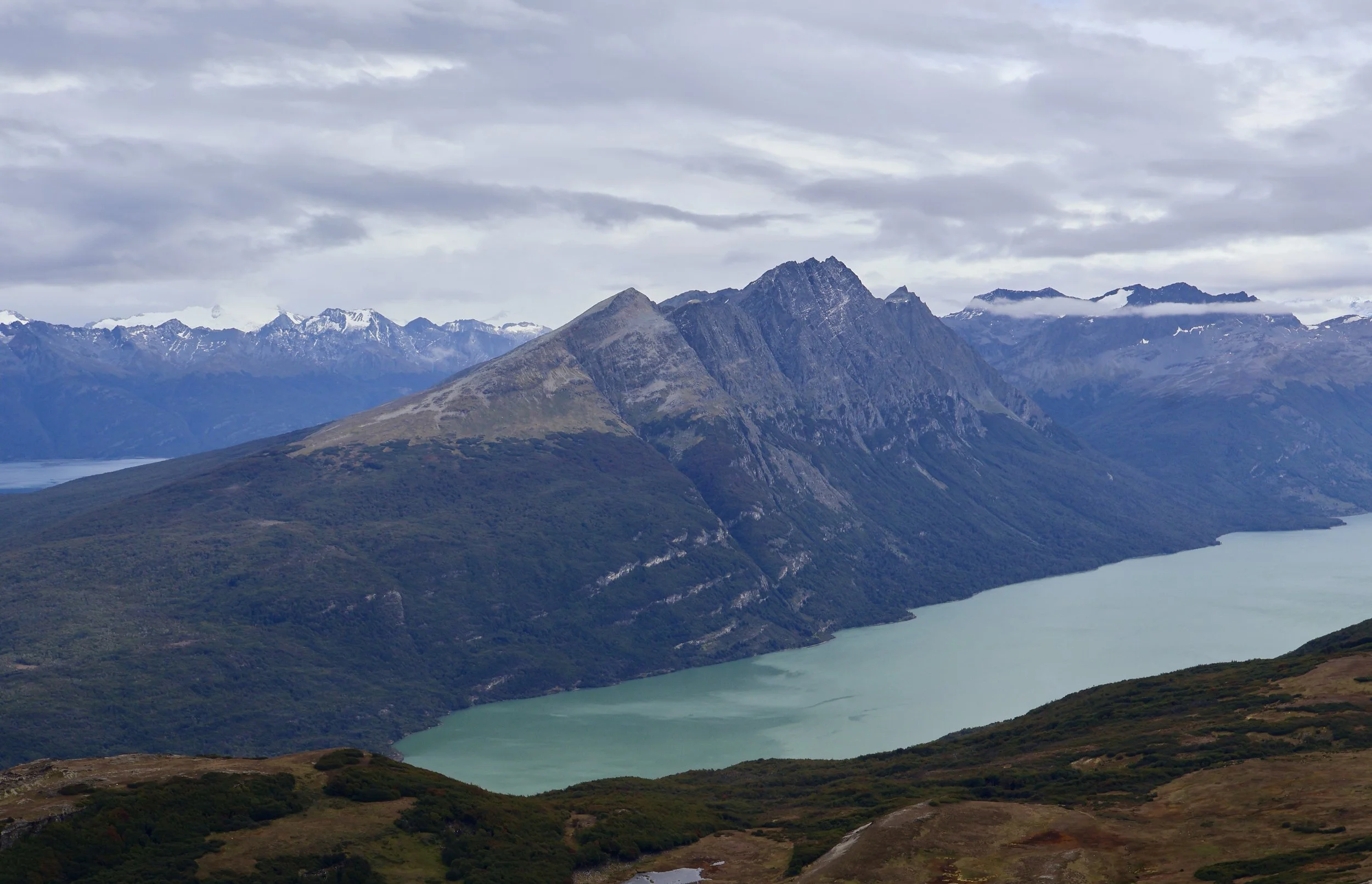
We checked out a few nice viewpoints over Ushuaia and the Beagle channel, and even drove on the only road leading out of town, the RN3, towards the north, to enjoy other views on the Andes mountain (at the Mirador del Valle Carbajal and the windy but gorgeous Paso Garibaldi).
Ushuaia, founded in 1869 by British citizen Waite Sterling, was actually inhabited by the Onawo, an indigenous people. Initially the site of a penal colony for Argentinian criminals, the city later grew thanks to fishing, gas extraction, farming and tourism.

Somewhere along the Senda Costera in the Tierra del Fuego National Park.
Today, Ushuaia is the gateway to the pearl of southern Patagonia, the Tierra del Fuego national park. One can access the park via the RN3 road, the only road leaving Ushuaia from the west. It dead ends at Lapataia bay, in the park.
On our first day exploring the park, we chose to hike the Coastal path (Senda Costera, hike details below in the Hiking section). It’s a fairly easy walk, so it was perfect as a park introduction, and the scenery along the Beagle channel was breathtaking. The trail starts in the Ensenada Zaratiegui bay, where the southernmost Argentinian post office is located. It’s nothing more than a basic prefab building on stilts over the water – I wondered how it could withstand the assaults of the elements – but it is a local attraction, for you can get special stamps to mail postcards, or even passport stamps, so it’s usually fairly busy. The place is also a must-do for guided tours and it’s likely you’ll see a few buses parked there, with the corresponding crowds snapping photos of the picturesque building, or waiting in line to get their stamps. Once you get on the trail however, the crowds thin out – tour bus groups do not have the time to walk the Sendera Costera, so you should be able to enjoy Patagonian nature with peace and quiet.
We didn’t hike the trail all the way – instead we turned around just before the path ascended towards the Alakush visitor center and went back. We felt we had seen the most scenic part and had to go around to pick up our rental car by the post office. We did see a couple of Andean foxes once we got back to the beach – a kind that’s bigger than your average fox, which is why I initially mistook them for coyotes.
Our second day in the park started early. I hadn’t been able to hike the Cerro Guanaco Summit trail in 2023, and really wanted to experience it this year. It is recognized as one of the hardest trails in the park, but the reward for climbing to the top is an incredible panoramic view over a good part of the park, all the way down to Ushuaia on one side, and to Chile on the other (hike details below in the Hiking section).
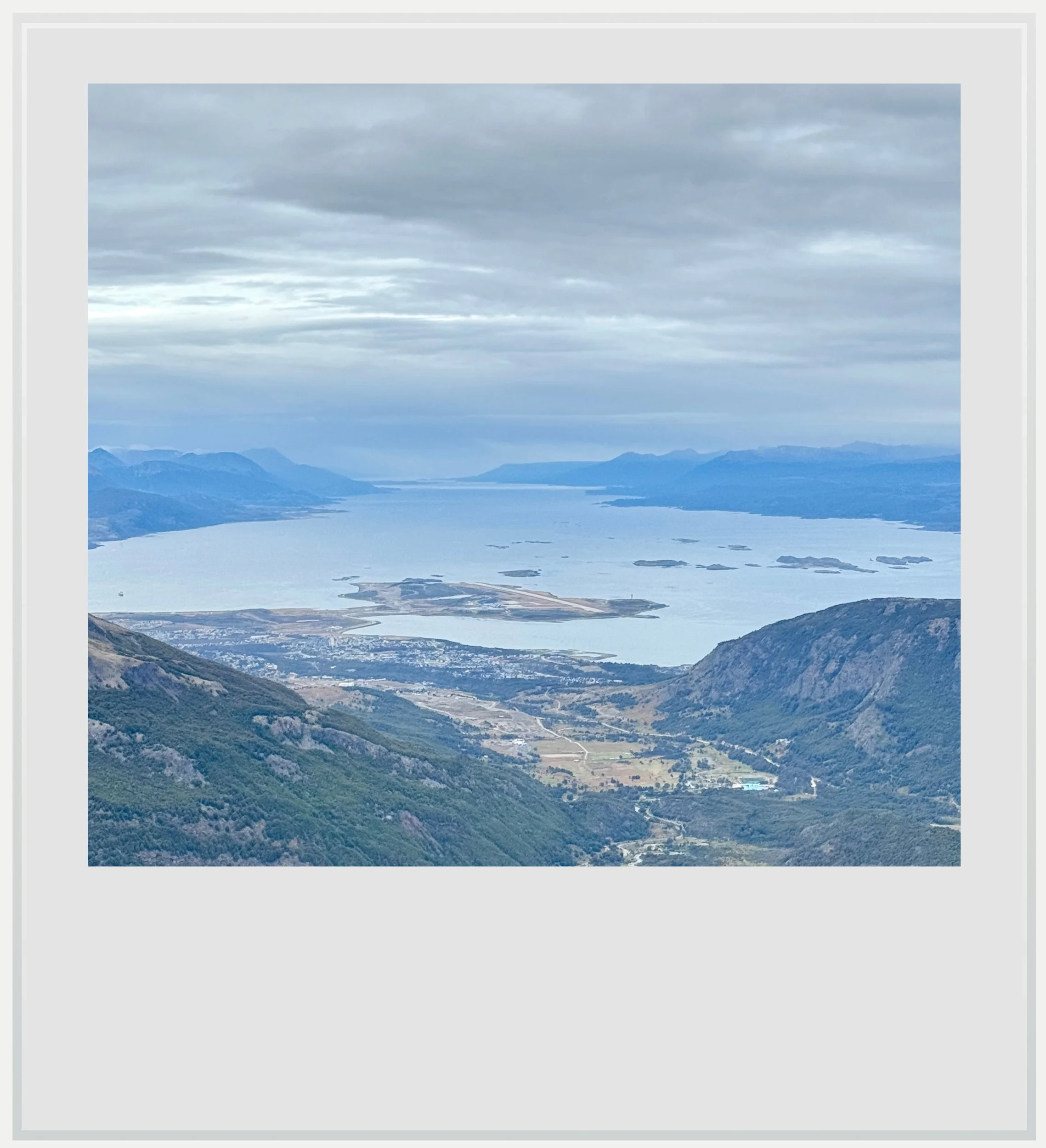
The view over Ushuaia and the Beagle channel from the Cerro Guanaco summit.
Being a difficult trail, we had to register before hiking (you can do this in person at the Alakush visitor center but we did it online). It is recommended to start the trail before noon. Like the rest of the park, the trail doesn’t have cellular coverage, so we were on our own the whole time. We did see a few people (maybe fifteen total, which was a lot less than on the Senda Costera) but this hike is overall uncrowded given its difficulty.
This was indeed a hard trail. Once we split from the Hito XXIV trail and started climbing in the forest, we could feel this wasn’t going to be a walk in the park. We did power through and took our time, checked out the viewpoint over Cerro Condor about one hour into the path, dealt with muddy parts beyond it, walked through the gorgeous peat bog area without getting too wet, and finally ascended on dry, rocky terrain on a steep path to the summit. As we were going up, the scenery was getting more and more beautiful, and we could see further and further away on the Chilean side, with mountains and lakes appearing in the distance.
This was nothing like what we discovered at the top, where we were treated to an almost 360-degree view over southern Patagonia, extending all the way to Ushuaia. It is hard to describe how we felt up there. At the top of the world may sound trite, but it summarizes it pretty well. There was a sense of pride for having achieved this feat, and a feeling of awe from seeing this impressive landscape at a high vantage point. I didn’t want to go back down.
On our third day… we took it slow. The Cerro Guanaco Summit trail hadn’t been too kind to our legs. It was tough to move them upon waking up in the morning. I took this as a good sign we actually worked them. We were unable to plan for another big hike, however.

The Lapataia bay viewpoint on the Mirador Lapataia trail.
As luck would have it, we had a few easy trails left to discover in the western section of the park. The area around Lapataia bay is fairly flat and home to six easy hikes, taking about thirty minutes each. They were the perfect antidote to sore legs. My favorite (as explained below in the Hiking section) was the Paseo de la Isla trail, which is the first hike we saw after crossing the Rio Lapataia bridge. It follows the edge of Lapatia bay where the water is shallow and emerald green, and it somewhat feels like you have landed on another planet. It’s also a lot less visited than the trails at the end of the road, like the Senda La Baliza.
The Tierra del Fuego National Park is a hiker’s paradise, and although there were a few more trails to check out, I felt we hit the main ones – but I would love to get back a third time to hike the ones we didn’t do!
We weren’t done hiking, however, as we flew to El Calafate the following day, and ended up in El Chaltén around 5pm, and went on a hike there right away. You can follow this story here.
Hiking in the Tierra del Fuego National Park (updated as of March 2025)
I was able to sample the best park hikes over two visits in the Summer of 2023 and 2025. November to April is the best season to enjoy them given the weather and the amount of daylight. Both times, I came to the park in March.
Hiking in the Tierra del Fuego national park: the Coastal Trail (Senda Costera)

The costal path trailhead, with the southernmost Argentinian post office in the foreground.
In a nutshell: 5 miles one way, easy for the most part, beautiful scenery along the sea shore. Elevation: 1843 ft. AllTrails link here.
This hike is one of the most iconic in the park, and is pretty easy, over mostly flat terrain. It starts here, near the Bahia Ensenada Zaratiegui, where the famous southernmost Post Office in the world is located (you can send special postcards and get your passport stamped, at a cost – USD14 for a postcard and international stamp, USD5 for a passport stamp). It ends at the Alakush visitor center. There are a few ways to do this hike. The easiest is to hike the path as a round trip, and this is pretty much your only option if, like us, you rented a car and left it parked by the Argentinian Post Office at the trail head. However, if you chose to come to the park via the shuttles mentioned below in the Practical Information section, you can get dropped at the trail head and picked back up at the Alaksuh visitor center, meaning you can get away with doing the hike one-way and not have to turn around. Finally, you may decide to only hike the first third of the trail, which is the most scenic, and turn right back (you’ll know it’s time to turn around when you get to a bay that ends with a wooden staircase leading you to a forested part of the trail). Thge advantage of this last solution is that you miss the elevated sections of the trail. The first third is basically flat.
You may see quite a few people at the very beginning of the trail, especially if tour buses are present. People in tour buses only get a few minutes to wander around so they don’t usually go very far on the trail, which means you’ll be enjoying the trail on your own after a few minutes.
Hiking in the Tierra del Fuego national park: the Cerro Guanaco Summit trail

The view towards Chile from the top of the Cerro Guanaco in the Tierra del Fuego national park near Ushuaia, Argentina.
In a nutshell: 8.5 miles round trip, 3422 ft in elevation. 4h30 out and back. Hard hike overall with incredible 360-degree vistas at the top. AllTrails link here. Registration needed, in person at the Alakush visitor center or online.
This hike was the highlight of our trip. It starts at Lago Roca (specifically here) and the first kilometer or so hugs the lake over flat terrain. It then splits from another trail that follows the lake all the way to the Chilean border (the Hito XXIV trail) and starts climbing through the native forest. This part is pretty strenuous, but you get to a mirador that makes it worth it after about one hour – you can see Roca Lake and Cerro Condor, the big mountain on the other side of the lake. Many people stop here, and it feels like a very rewarding hike already. If you continue, be aware that while the climb is a little less steep at first, it will get a lot muddier. It isn’t muddy if you compare it to the notoriously messy Laguna Esmeralda hike, but it does get messy: you will need waterproof hiking shoes. Do not intend to hike this trail with sneakers.
After passing a few muddy areas, you’ll exit the forest and get into a wide, beautiful peat bog. It is fairly flat, for a change, but it’s treacherous. The peat bogs are drench in water and it’s very easy to get your shoes wet.
The hardest part of the hike starts once you cross the peat bogs and starts walking along the side of the actual Cerro Guanaco. The trail is fairly straight and smooth, though over barren, rocky terrain. The real killer, however, is the incline, which, according to AllTrails, can be as steep as 80% in some portions. It is challenging. Take your time, stop as much as you need to enjoy the views to the west (on your right as you climb). As you get higher and higher, mountains, valleys and bays gradually appear, and it’s a truly beautiful sight.
Once at the top, you’ll see an open area with a wide view, but the trail continues, and so should you. Once you climb a little more towards the right and go around a rocky area, you’ll get to the very end of the trail and will be rewarded by an incredible 360-degree view over the park and beyond. You can clearly see Ushuaia and its airport in the distance to the east, and Chile to the west. It can get cold and windy up there so don’t forget your gloves and your hat.
The descent is actually hard too. The steep incline on the way in will be tough on your legs, so take caution. We were pretty beat for a couple of days after the hike, but the views were absolutely worth it.
Hiking in the Tierra del Fuego national park: small trails around Lapataia bay

Laguna Verne, at the end of the Paseo de la Isla trail.
In a nutshell: 6 short, flat hikes around Lapataia bay, most will take around 30 minutes. They are easy, well-marked, and will let you enjoy nice vistas of the bay or nearby lagoons.
We did almost all of the hikes in this area, which is the furthest away in the park, where the RN3 road ends, 1913 miles from Buenos Aires. This can be a great way to spend a tranquil half-day in the park (perfect if you hiked the Cerro Guanaco trail the day before and need a little bit of a rest).
My favorite hike was the Paseo de la Isla (easy, mostly flat, 40mn loop, AllTrails link here). The trailhead is actually right after the bridge over the Rio Lapataia (here), not at the end of the road with the other hikes, with parking nearby. It will bring you over the northern tip of the bay, where the water color is actually a delicate shade of green (you’ll probably snap a bunch of pictures throughout the hike). Once you reach the road, do not go back yet. Follow the RN3 to the left for a few hundred feet and you’ll get to a small trail on the right, leading you to the Laguna Verde viewpoint (part of it was off-limits when we went, but its very easy to get around the wood work and get a fantastic view over the lagoon). You can then turn back and get back to the car park via the road.
My second best hike was called Mirador Lapataia (easy, mostly flat, 45-mn loop, AllTrails link here). It starts from the car park at the end of RN3 (here), gets you to a nice elevated viewpoint above the bay (currently partly closed, but you can go around the closed area to get a good view), then heads into the forest, passes by a beautiful, colorful peat bog and ends on the RN3. Turn left and head back to the parking lot.
Practical information (updated as of March 2025)
Getting to Tierra del Fuego National Park
- Getting to Ushuaia from the US: Ushuaia airport is the closest one to the park. Although technically the southernmost international airport in the world, actual international flights are seasonal and originate in neighboring countries. As such, your best bet to get to Ushuaia from the US is to fly into Buenos Aires’ intercontinental airport, Ezeiza (EZE) and catch a 3.5-hour connecting flight from there. Aerolineas Argentinas, the country’s flag carrier, offers at least one daily flight between EZE and USH airports, while low cost JetSmart and FlyBondi link the two several times a week. A quick Google Flights search will let you know what are your options on the day you’d like to fly.
- Getting from Ushuaia to the park: Ushuaia will likely be where you’ll stay during your visit. There are four main ways you can get into the park from there. A) rent a car at the airport or in town. This gives you the most freedom to come and go in the park pretty much as you want. B) take a combi from downtown (at the corner of Fadul and Maipú streets, here). These are scheduled buses that serve as an unofficial shuttle between Ushuaia and the park. They don’t come super often so you’ll need to plan you pick up, both in Ushuaia and in several points in the park, but it is the most cost-effective option. As of writing, the price is USD7 one-way C) take a taxi to and from the park – it gives you more flexibility but unless you ask your taxi driver to wait for you, you’re at the mercy of not having a ride back (and you can’t take the shuttle one way, so that can’t be your back up). D) join an organized day trip to the park. It’s convenient but you’ll have less opportunities to do things are your own pace.
- Entering the park: the park is open from 8am to 8pm every day, although the best time to go is between November and April. The entrance fee is ARS30,000 per person for one day (about USD27), however if you purchase 3 days at once, it will only cost you ARS60,000 (and ARS105,000 for a 7-day pass). If you’re planning to stay in Argentina for a bit and visit other parks, an annual pass for all Argentinian national parks is available for sale for ARS225,000. Information (in Spanish) here.
Safety
- The US State Department labels Argentina as a level 1 country, meaning “Exercise normal precautions” when you travel. In fact, Austral Patagonia is extremely safe, probably due to its location at the end of the world. My only advice would be to use common sense, but I have never felt remotely unsafe while in or near Ushuaia.
Food
We didn’t try any local restaurants on this trip. The Argentinian peso is pretty expensive right now, and, Ushuaia being very remote, prices are high anyway, so it felt like two good reasons to cook our own dinners. We did check a few bakeries to find sandwiches for our hikes though.
- Panaderia La Familia – among the five or so bakeries we tried, this was the one that offered the tastiest sandwiches. Their white bread was tasty, not too heavy and the fillings were generous. I recommend.
- Marco Polo café. Located in the Cap Polonio hotel, this fancy café serves delicious and copious (if a little pricey) salads to go, which were a great alternative to our lunch sandwiches.
Photos from top to bottom: the western view at the top of Cerro Guanaco (main picture), the view from the Valle Carbajal viewpoint on the RN3 road north of Ushuaia, somewhere along the Senda Costera in the Tierra del Fuego National Park, the view over Ushuaia and the Beagle channel from the Cerro Guanaco summit, the Lapataia bay viewpoint on the Mirador Lapataia trail, the costal path trailhead, with the southernmost Argentinian post office in the foreground (photo courtesy of my mother), another view towards Chile from the top of the Cerro Guanaco in the Tierra del Fuego national park near Ushuaia, Laguna Verde, at the end of the Paseo de la Isla trail.
All photos are mine unless otherwise noted.