Four Days hiking in El Chaltén, Argentina.
Enjoying amazing scenery in the hiking capital of Argentina.
I came back to Argentina in March 2025, after having visited the country for six weeks in 2023. This is the second article of the series. We started our trip by hiking the Tierra del Fuego National Park near Ushuaia, a few days earlier. After El Chaltén, we headed out to the Perito Moreno glacier in El Calafate. Our full, three-week itinerary and how it came together can be found here.
Landing in El Calafate airport, the gateway to the Parque Nacional Los Glaciares, felt like a very different experience from Ushuaia, a few days before. The landscape here was barren, with bright blue lakes and rivers streaking the dry land. After getting off the plane, we had a light lunch in the one restaurant in the airport, then boarded our Chaltén Travel bus to the northern portion of the park.
The Glacier National Park is huge, at more than 2,800 square miles, and is actually part of an even bigger protected area including Chilean national parks on the other side of the border. In Argentina, it is divided into two regions, the northern one, where El Chaltén is located, and the one near the Perito Moreno glacier, which we would visit next.
Being an avid hiker, I had heard of El Chaltén before my first visit to Patagonia in 2023. The hike to the base of the FitzRoy mountain is known in hiking circles as one of the most beautiful in the world, and I felt it was calling me. I did it once in 2023, and did it again in 2025, this time with family.
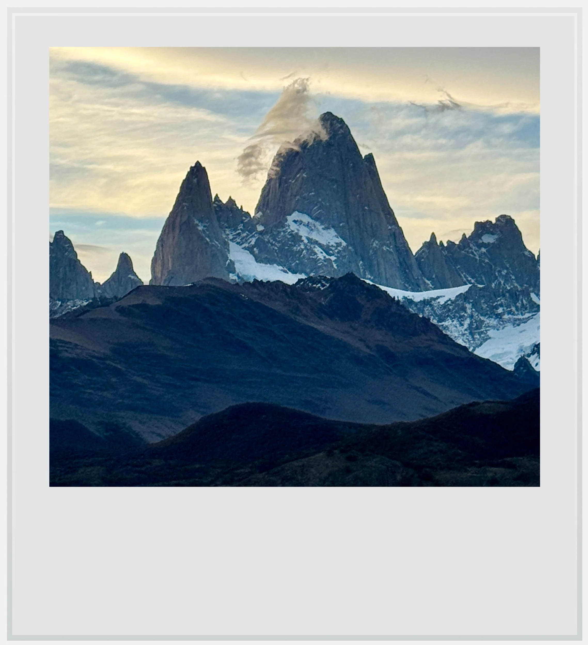
Mount FitzRoy seen at sunset from the Condor viewpoint in El Chaltén.
It would be wrong to reduce El Chaltén to its most famous hike. The area around the village is replete with many trails for all levels, all offering stunning vistas. While the region is fairly famous in Argentina and within the hiking world, it still feels like an undiscovered gem, filled with backpackers and relatively few foreign tourists. I was excited to go back.
For a good part of the two hour and a half trip, our bus drove along Viedma Lake, a beautiful, bright blue glacial lake whose waters comes from the nearby Viedma glacier. As in most parts of remote Argentina, there was no cell service during the trip, yet I was relived to notice a strong LTE signal once we got to El Chaltén (I used a Saily eSIM for this trip, which relied on the Movistar Argentina network). I hadn’t been this lucky in 2023, and it took it as a sign the small town was developing further, and catering more and more to tourism.
The history of El Chaltén is a fascinating one. The town is the youngest one in Argentina, having been founded in 1985. In the late 20th century, Argentina and Chile were embroiled in a territorial dispute over who owned a part of land close to the Lago del Desierto and the Southern Continental Patagonian ice. To strengthen its claim, Argentina decided to settle the area at the confluence of the Las Vueltas and FitzRoy rivers, and the town was born. The dispute was mostly solved in 1991 but parts of the region are still technically claimed by both countries.
The town draws its name from the ancient name for Mount FitzRoy. Before 1877, the mountain was actually called Cerro Chaltén, which meant “smoking mountain” in the language of the indigenous people living in the area. They believed at the time that the mountain was a volcano for it was almost always surrounded by clouds. Francisco “Perito” Moreno, a famous Argentinian explorer whose name was given to the most stunning glacier in southern Patagonia, proposed renaming the mountain to honor Robert FitzRoy who, as captain of British Royal ship HMS Beagle, had previously traveled up the Santa Cruz River in 1834 but failed to reach the mountain.

A partial view from the Cerro Torre viewpoint on the laguna Torre hike in El Chaltén.
We arrived in El Chalten around 5pm on our first day, and while it was too late to begin one of the most famous hikes after checking in, getting settled and finding a laundromat to get clean clothes, we still wanted to get up a mountain, so we picked a short, somewhat easy hike to the Mirador de los Condores, or Condor viewpoint (like all hikes discussed here, you can find all the details about them in the Hiking section below). It took us about forty-five minutes to the summit, from the center of town, first crossing the FitzRoy river and then gradually climbing among thorny shrubs. It was windy at the top, a constant in almost all the hikes we did in the park, yet the view made us forget about it. While we weren’t super high, it was enough to get above the mountains on the other side of the rivers that border el Chaltén, and as such, we were offered a 180-degree view over some of the most famous peaks in southern Patagonia, with Mount FitzRoy being the highest. We watched the sunset there, and it was truly stunning. Once the sun disappeared, it got noticeably colder, and we quickly retreated back down for dinner, and an early night. We had to get up early the next day.
Indeed, my alarm rang at 6am on day two, and we managed to get out of the house just after 7am. I wanted to climb to the Laguna de los Tres on our first full day, provided the weather was cooperating, and it was. The Laguna de los Tres hike is the one hike that put El Chaltén on the world’s hiking map, and I wanted to climb it with my fellow family travelers. Getting out early meant less people on the trail on the way up, and potentially better weather, as afternoons tend to be a little less sunny than mornings around there.
The most iconic hike in the northern region of the park, the Senda Laguna de los Tres is a long, sometimes very strenuous walk towards a glacial lake sitting in front of one of the most striking landscape in Argentina, a lineup of jagged, vertical peaks, with Mount FitzRoy towering above all the others.

The laguna de los Tres and laguna Sucia, the two prizes at the end of the Laguna de los Tres hike.
Unlike in 2023, the park now charges for entrance (details in the Practical Information section below) and the Laguna de los Tres is one of the trails where the fee is enforced. After showing our passes to a park ranger, we started our hike. The first viewpoint, about forty-five minutes into the climb, lets you see the Vueltas river valley from a few hundred feet of elevation, and the mountains looked incredible in the morning light. Another forty-five minutes or so later, we reached the FitzRoy viewpoint. After this, and a bunch of climbs and descents, we got to the Poincenot campground, a great place to spend the night if you want to see the lakes at the bottom of Mount FitzRoy in the early morning. We then crossed a river, and got to the last rest area before the final ascent.
At that point, there are signs posted to remind you the rest of the hike is hard, and although I knew it from my previous trip two years before, it was still a tough climb.
Still, we did it. We took our time, drank a lot of water, and finally made it to the top. There is a sense of elation when you get there that you can feel in everyone sitting around the lake, as if we were all silently congratulating each other for having eventually made it. We were famished so we ate, then walked a little more to see the Laguna Sucia (dirty lake), an ever bluer glacial lake hidden on the left of the panorama. To me, that’s the actual best thing to see up there, so don’t miss it, no matter how tired you are at the top.
The descent, as I remembered, was a little complicated, for you have to go slow to avoid slipping and falling, without bowing to the pressure of people going down faster than you, or groups eagerly going up (and asking you “how much farther?”). We breathed easier once we got to the rest area at the end of the steepest part of the descent, and the rest of the hike was fairly easy, except for the lingering pain in our shins and knees.

The view over lake Viedma while climbing the Mirador de las Vueltas hike.
On day three, the weather was going to turn to rain in the afternoon, so it was the perfect excuse to take it slow. Indeed, we chose to hike the Chorillo del Salto trail in the morning. One of the easiest trails in the park, it follows the Las Vueltas river for most of its way – it’s completely flat, and after about forty minutes, gets you to a beautiful waterfall. It’s a nice spot to chill, and it wasn’t super crowded when we got there.
In the afternoon, we ambitiously aimed to hike the El Paredon trail counterclockwise, to first visit the Las Vueltas viewpoint on the eastern side of the valley. The climb up to the mirador is short but strenuous, and we hadn’t signed up for it after the previous day’s hike. Because the weather was quickly deteriorating, we turned back after the viewpoint. All in all, the hike we did was called Las Vueltas river canyon, and it took us an hour, but the view made it worth it – since it is one of the only hikes getting you to the other side of the Las Vueltas valley, the panorama felt different from anywhere else in El Chaltén.
On day four, the weather was better, though windy, and we left around 8am to hike the Laguna Torre trail, the second most famous hike in El Chaltén. It’s a long hike but its definitely easier than the Laguna de los Tres, and because it’s free when the other isn’t anymore, you’re likely to see more people on it. Starting early means a less crowded experience, at least on the way up. The hike follows the Rio FitzRoy for most of the way, and while the path is a little steep in parts, there are many flat sections to compensate. The early fall colors were on display throughout the valley, a mix of green, yellow, orange and red that made the mountains even more beautiful.
The laguna Torre, at the end, is remarkable, not really for its grey waters but for the many small icebergs dotting its surface. It’s unexpected and makes for a great scenery. Behind the laguna, you can see the massive Maestri glacier, which you can get close to if you choose to continue a little more. It was too windy for us to do. I had gone in 2023 and didn’t feel like doing it again with such wind.

The mini icebergs of Laguna Torre against ominous clouds.
The descent was rather easy, and the wind eased as we lost altitude. We were back in town in the early afternoon, and enjoyed a nice hot drink before making our way to the bus terminal, where a Chaltén Travel motor coach would get us to our next destination, El Calafate, so we could visit the Perito Moreno glacier the next day.
Hiking in the Tierra del Fuego National Park (updated as of March 2025)
Hiking the Glaciares National Park in El Chaltén: Laguna de los Tres hike

The Laguna de los Tres, at the end of the namesake hike, with a clouded over Mount FitzRoy in the background.
- In a nutshell: 13.5 miles (9 hours) round trip. 3400 ft elevation gain. A moderate hike up until the last 90 minutes which are very hard but worth the effort. AllTrails link here. This hike will take all day. While you may finish around 5pm if you start at 7am and spend a little bit of time at the top, you’ll be too tired to do anything else after that.
- This is the most famous hike in El Chaltén and one we couldn’t miss, The hike starts at the northern edge of town and is well marked all the way to the top. The first 90 minutes or so will see you climb up above the village, which you see behind you in the beginning, stop at a beautiful mirador over the Rio Las Vueltas valley, which, if you leave town around 7am in the summer, you should hit around the time the sun appears behind the mountain line, giving the valley beautiful warm hues, and end at the mirador FitzRoy, when you can take a break and enjoy the view over the most famous peaks in Argentina, including the famous cerro FitzRoy.
- After this first part, you’ll walk in a gorgeous valley for bit, then climb again to the Poincenot campground, pass a river and get to another rest area (with benches) before you ascend the last part.
- That last part of the trail starts with a warning sign that you really need to be in great physical shape to get to the top, and it is true. From there, the climb rate is higher and most of it happens in a rocky, treacherous, steep riverbed that seems like it will never end… only to be replaced by an even steeper path through rocks that can be narrow at times.
- It’s not for the faint of heart, but at the same time, it can be done. Take your time, take some breaks, let the (many) people pass you if needed, and you’ll eventually make it to the end.
- At the top, you’re getting another viewpoint over the highest peaks in the region, with mount FitzRoy being the highest, but from much closer and with a bright turquoise glacial lake at the bottom that adds a special oomph to the landscape. It’s hard to explain how we felt once we ended the climb. We were so tired that even the most basic of views would have fulfilled us, but this wasn’t basic at all.
- Once you’re somewhat rested and you have eaten and drunk a bit, you’ll be ready to go down towards the lake and then back up to the left of it to check out the even brighter yet weirdly named Laguna Sucia (dirty lake), a deep glacial lake you can’t really get close to given how steep the terrain is there, but you get to see the glacier, the torrents of water coming from it and feeding the lake as well as the lake itself, and it’s a sight to behold.
- Additional things to note on this hike:
o there is a checkpoint at the beginning of the hike where park rangers will check your entry pass, so unless you’re ready to find another access with no checkpoint to save the entry fee, you’ll have to pay. I am told the booth is manned from 7am to 8pm. This hike was free when I first did it in 2023, and the access fee has been controversial (more details on the park’s fee structure can be found in the Practical Information section below).
o the hike can get busy to super crowded, which is why both times I hiked it, I started around 7am. The sun wasn’t out yet, but there was enough daylight for it to be a viable endeavor. The only time the crowds can be challenging (beyond at the top) is going down the hardest part of the path. Because it is rocky, narrow and a lot of rocks aren’t stable, you’ll be tempted to accelerate to pass between groups coming up, and if you go too fast, it can be easy to trip and fall. Take your time, let people in front and behind you pass you if needed, and you’ll be fine.
o At some point, the trail splits in two possible paths (which merge about twenty minutes later): one passes by the FitzRoy viewpoint which I mentioned, and another one hugs the Laguna Capri for a bit. I suggest you go via the viewpoint on the ascent, it is likely to be less cloudy then, and pass by the Laguna Capri on the way down. The split is very well signaled on the trail.
o You can get to the top of the hike via other ways as the trail system is pretty much interconnected. Another popular way to climb to the Laguna de los Tres is to start from Hosteria El Pilar (Alltrails link – 12.9 miles round trip, 3,077 ft elevation gain) but you’ll need a car as the trailhead sits about 10 miles from El Chaltén. There is a park checkpoint there as well. The added bonus of this path is the beautiful view over the Piedras Blancas glacier.
Hiking the Glaciares National Park in El Chaltén: Laguna Torre hike

The laguna Torre and Maestri glacier, at the end of the Laguna Torre hike.
- In a nutshell: 11.4 miles round trip, 1,748 ft elevation gain. 5h to 6h out and back. Moderate hike overall with sweeping vistas and a glacial lake full of icebergs at the end. AllTrails link here.
- The second best hike in El Chaltén by popularity, the Laguna Torre hike is easier than the famous Laguna de los Tres, yet provides a similar viewpoint at the end, over the Laguna Torre, mount Torre, and the majestic Maestri glacier.
- The hike starts on the western side of El Chaltén (here), and starts climbing above the village, follows the Rio FitzRoy valley for a while, and continues to climb all the way to the Cerro Torre viewpoint, a little over an hour after the start. This is a great rest stop with benches so you can enjoy the spectacular view (as long as clouds cooperate).
- After the viewpoint, the trail descends a little bit and then follows the valley until then end, crosses a dry riverbed which isn’t super well signposted but fear not, all paths lead to the other side, where you’ll climb again before reaching the laguna.
- The laguna itself is beautiful, almost as much as the laguna de los Tres, with the huge Maestri glacier in the background and many small icebergs dotting the lake’s surface, highlighting its grey waters with specks of white.
- We hiked on a day where the wind was a little strong, and we could feel it on the hike, but it was nothing like what welcomed us at the top, where we had to take shelter to have lunch (there are a few makeshift wood shelters behind which you can hide, and it really helps). As a result, we didn’t even try to continue further to the mirador Maestri, as its path lies on the western side of the laguna, on a very exposed ridge. Make sure you layer up for this hike.
- There is no park checkpoint for this trail, which means you don’t have to pay for access if you don’t want to.
Hiking the Glaciares National Park in El Chaltén: Mirador de los Condores hike

The view from the Condores viewpoint, with mount FitzRoy on the right.
- In a nutshell: 1.6 miles roundtrip (1 hour), 423 ft elevation gain. Easy. AllTrails link here. A great hike if, like us, you arrive in El Chaltén in late afternoon and want to get going right away, or as part of a slower day between longer hikes. The view at the top over the valley and the famous El Chaltén peaks behind it is glorious.
- This one is the definition of a low-effort, high-reward hike. The trailhead is on the southern side of town (here). The ascent is gradual (although when you look at the summit from the road at the bottom, it feels like it will be tough, it isn’t) and the panoramic view at the top gives you a good overview of what El Chaltén is about. We were there to see the sun set behind the mountains, and it was beautiful.
- It can be very windy at the top, especially with the sun gone, so while you may not feel like layering up, do it anyway so the time you spend at the viewpoint is comfortable.
- We did see a few condors as we climbed, so I can vouch for the name of the trail not being a marketing gimmick.
- There is an opportunity to climb higher from the viewpoint: you can indeed ascend to the Mirador de las Aguilas (Eagles lookout). It’s a 4.5 miles hike roundtrip with a total elevation gain of 1,000 ft. We didn’t do this but AllTrails labels it as a moderate hike. It will be on my list if I ever come back to El Chaltén.
- There is an official park checkpoint at the beginning of the trail, past the trailhead. It wasn’t manned when we passed it, but in theory, you’re supposed to pay the park fee to hike this trail (more on this below in the Practical Information section).
Hiking the Glaciares National Park in El Chaltén: Chorillo del Salto hike

The Chorillo del Salto waterfall in El Chaltén.
- In a nutshell: 4.1 miles round trip, 90 minutes out and back, 456 ft elevation gain. Easy hike on flat terrain. AllTrails link here.
- We hiked this trail on our third day, sandwiched between two harder days, and it was the perfect morning workout: easy enough that our sore legs didn’t mind it too much and with beautiful scenery on the way and at the end, where we got to see the Chorillo del Salto waterfall. It is likely you’ll see families with children on the trail as it’s one of the easiest in the park.
- The hike starts from the same trailhead as the Laguna de los Tres hike (here), right after the park checkpoint. This means you technically have to have a park ticket to access it, but since the trail closely follows the dirt road leading towards Lago del Desierto, you can walk on the road at first to avoid the checkpoint, and join the trail a little later.
- Whether you seek to avoid the checkpoint or not, a little part of the trail is shared with the dirt road, which means cars passing you by will deliver a generous portion of free road dust. Thankfully, this part of the path isn’t too long.
- You can opt to walk the last hundred yards of the trail by taking a car all the way to the parking spot that’s close to the waterfall. It isn’t as much fun (and won’t burn nearly as many calories), but if you have a car and are short on time, it can be a possibility.
Hiking the Glaciares National Park in El Chaltén: Mirador de las Vueltas hike

The view over el Chaltén from the mirador the las Vueltas, on the other side of the valley.
- In a nutshell: 2.3 miles, 90 minutes out and back, 980 ft elevation gain. A moderately hard hike, short but with a very steep section. AllTrails link here.
- We hiked this trail on day three, in between two harder hikes. We had done the Chorillo del Salto hike in the morning, and were trying to do a longer loop hike, but the weather had other plans, so we ended this hike at the mirador and went back down.
- The hike is one of the few that start on the other side of Rio de las Vueltas (here), and sits on private property, so it’s not technically in the national park. Once you cross the bridge, take the entrance to the right. There is a “private” sign but the gate was open and we saw many other hikers on the path. I don’t recommend hiking this trail if the gate is closed, but I am told it rarely is. This hike is free.
- The first part is flat and follows the river to the south, before turning left and ascending to the top of the canyon. The hike is very steep, almost uncomfortably so in parts, and we had to go slow. The hard part lasts about 15 minutes.
- The reward is a sensational view over El Chaltén and the mountain range behind it, from a different vantage point as many other hikes. The cliffs being closer to the village on that side, you almost feel you can touch the houses down below.
- Be careful going down if you chose to turn back like we did, since the path is mostly dirt and slipping is easy.
Practical information (updated as of March 2025)
Getting to El Chaltén
- Getting to El Chaltén from the US: El Calafate airport (FTE) is the closest commercial airfield to El Chaltén. There are no direct flights to El Calafate from the US - the only international flight is a biweekly service to Santiago de Chile in the summer. Aerolineas Argentinas, the country’s flag carrier, flies to El Calafate from several airports, including Buenos Aires Ezeiza, where all US flights arrive. It also offers flights from Trelew (REL) , Bariloche (BRC), Ushuaia (USH) and other airports, which can be useful if, like us, El Chaltén is only one stop of many in the country. Low cost airlines JetSmart and FlyBondi also operate to El Calafate from Buenos Aires and Ushuaia. Check Google Flights to see what flights are available the day you’d like to travel, as, while Buenos Aires is served multiple times daily, other destinations may not have daily flights.
- Getting from El Calafate airport to El Chaltén: you can rent a car in El Calafate airport and drive 2h30 to El Chaltén. Most people, however, take a bus. Several companies offer transfers from El Calafate proper, that stop at the airport on the way to El Chaltén. Both time, I chose Chaltén Travel, but other similar companies, such as Marga Tacsa and Cal-Tur, provide the same service. Pick based on the traveling times that suit you best.
- Entering the park: this portion of the park is technically open 24/7, although I don’t recommend going hiking in the dead of the night for obvious reasons. Park rangers man the access points between 7am and 8pm, which means if you get in the park before that time, you won’t have to pay the access fee for the hikes that need it (see details above in the Hiking section). The entrance fee itself is ARS45,000 per person for one day, however if you purchase 3 days at once, it will only cost you ARS90,000 (and ARS157,500 for a 7-day pass). If you’re planning to stay in Argentina for a bit and visit other parks, an annual pass for all Argentinian national parks is available for sale for ARS225,000. Information and latest prices (in Spanish) here.
Safety
- The US State Department labels Argentina as a level 1 country, meaning “Exercise normal precautions” when you travel. In fact, Patagonia is extremely safe, probably due to its location at the end of the world. My only advice would be to use common sense, but I have never felt remotely unsafe while in or near El Chaltén.
Food
Panaderia Lo de Haydee – we take our sandwiches seriously, especially when eaten at the top of a strenuous hike. Among the bakeries we checked out in El Chaltén, Lo de Haydee had the best ones (and pretty good to-go alfajores as well).
Simple – a small, fancy grocery store by El Chaltén standards, Simple has the best salads in town, period. They are on the pricey side (from ARS12,000), but they’re really good value for money.
Patagonicus - tasteful filling, gigantic pizzas, to stay or to go. A half-one will be enough for most people.
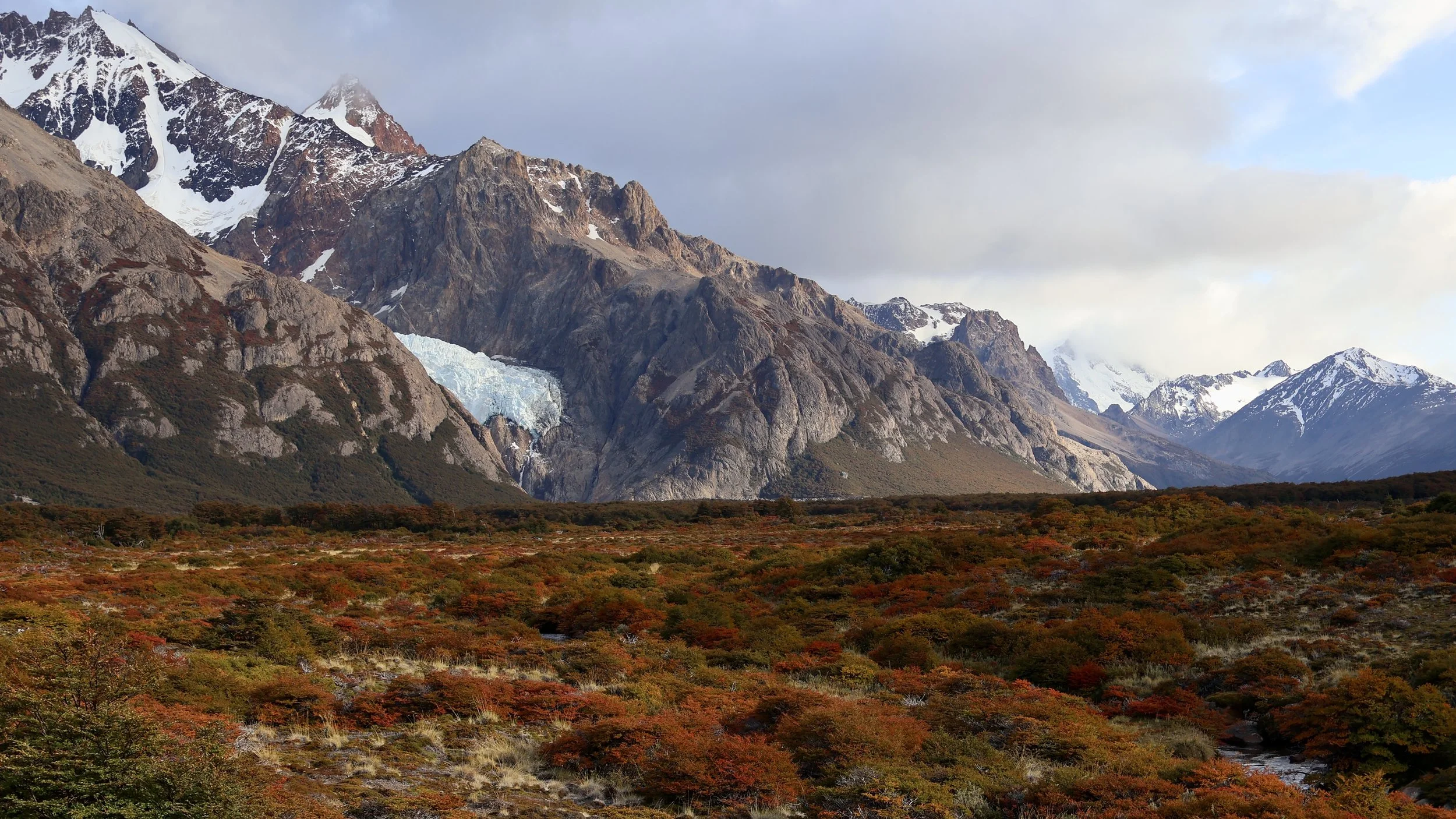
Photos form top to bottom: a view over the Piedras Blancas glacier while hiking the Laguna de los Tres (headline photo), Mount FitzRoy seen at sunset from the Condor viewpoint, a partial view from the Cerro Torre viewpoint on the laguna Torre hike, the laguna de los Tres and laguna Sucia, the two prizes at the end of the Laguna de los Tres hike, the view over lake Viedma while climbing the Mirador de las Vueltas hike, the mini icebergs of Laguna Torre against ominous clouds, the Laguna de los Tres, at the end of the namesake hike, with a clouded over Mount FitzRoy in the background, the laguna Torre and Maestri glacier, at the end of the Laguna Torre hike, the view from the Condores viewpoint, the Chorillo del Salto waterfall, and the view over el Chaltén from the mirador the las Vueltas, on the other side of the valley.
All photos are mine.