Four Days in Northwestern Argentina.
In and around the stunning Quebrada de Humahuaca valley and its surroundings.
I came back to Argentina in March 2025, after having visited the country for six weeks in 2023. This is the fifth article of the series. We started our trip by hiking the Tierra del Fuego National Park near Ushuaia, then flew to El Calafate to hike in El Chaltén and see the amazing Perito Moreno glacier. After that, we traveled all the way to the northern part of the country to discover the Iguazu Falls. Our final stop before checking out Buenos Aires was the Quebrada de Humahuaca region, in the northwestern part of the country. The full itinerary and how it came together is described here.
After a little more than two days walking among the luxuriant jungle surrounding the Iguazu Falls, we took a taxi back to IGR airport, a mere twenty-minute ride from town. It was relatively early on a Saturday, the heat wasn’t oppressive yet, and the city felt like it was still asleep. The drive was fast and we got to the small airport in no time.
Two hours later, we landed in Salta. We hadn’t planned to visit the city, although it features on most Northwestern Argentina itineraries, but the only flight going towards our final destination that day was landing there. It beat backtracking through Buenos Aires and saved us several hours of travel.
Our ultimate goal was to discover the many sights of the Quebrada de Humahuaca, the narrow mountain valley seeing the Rio Grande flow, north of Jujuy, famous for its stunning displays of colors on arid mountains and a UNESCO World Heritage site since 2003. It also has a rich history as a historical trade route between the Andean plateaus and the south of the continent.
Yet we were starting the last portion of our journey through Argentina in Salta, and we decided to give the city a short day.
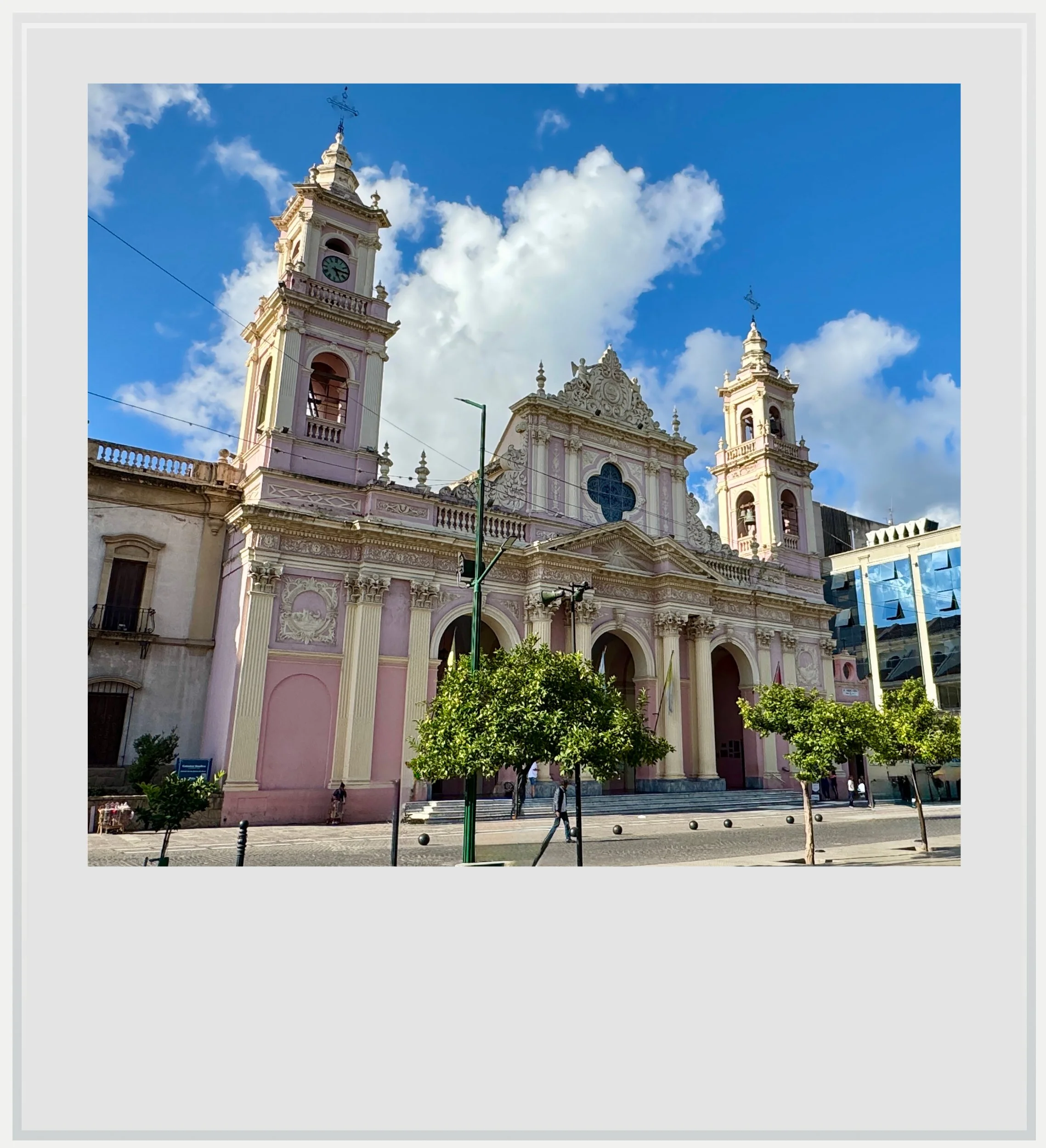
Salta’s cathedral, on the July 9 square.
The city itself was founded in the 16th century by Spanish settlers wishing to create a stop on the Buenos Aires to Lima route. During the independence war, Salta became a very important focus point, as the area, closer culturally to present-day Bolivia and Peru, was seen by the Spaniards as easier to keep than the rest of Argentina. Today, it is the biggest city in the eponymous province, and serves as its economic and cultural center.
It is notable that most Salta listicles feature a lot of attractions away from the town. While pleasant, Salta wasn’t a highlight of our trip, but can be a great base camp to explore the surrounding region.
Once in Tilcara, I realized quickly this was a different part of Argentina.
We did wander through the centro histórico and enjoyed the sight of a few notable historical buildings, especially around the main square, Plaza 9 de Julio, as well as the magnificent Basilica Menor San Francisco, a few blocks away. Although initially built during colonial times, the church was destroyed by a fire in the 18th century and rebuilt then, with strong Italianate influences.
After a nice stroll in the town center, which took us a little more than an hour, we felt a hike was rather a propos, and ventured towards the Cerro San Bernardo, a popular local hill with sprawling views over Salta. It is possible to take a taxi or a cable car all the way to the top but we opted to walk the 1071 steps with many Salteños and their dogs.

A shop front in Tilcara.
On Sunday morning, technically the first full day of our four-day trek in the region, we drove all the way to Tilcara, a cute somewhat touristy town smack in the middle of the Quebrada, which we would make our base for the next few days. I had picked it because it was one of the highlights in all the guides I had read, and because we could go pretty much anywhere in the Rio Grande valley from there for a day trip.
It turns out the town was much more than a basecamp. Its center is a beautiful maze of colonial architecture, cute restaurants and shops, patroned by locals and street dogs alike. There is a distinct energy there, that feels at the same time magical and, for now at least, authentic.
That’s not to say the town was void of tourists. Indeed, the feeling was a fragile balance of local and foreign, a town that hasn’t been yet put on the map by anyone, that only a limited amount of travelers get to find on a map and explore. Some shops were selling beautiful but overpriced artesanias, and the craft market on the main square was definitely geared towards the transient, yet the town felt overwhelmingly local, peaceful and beautiful.
Once in Tilcara, I realized quickly this was a different part of Argentina, one with deep cultural and historical ties to the upper Andes region of Bolivia and, further north, Peru. The region has the highest concentration of indigenous people in the country, and while tourists feel they can blend in anywhere near Buenos Aires, it is a much harder feat in the Quebrada.

The sunrise is about to hit the closest mountains to the Rio Grande valley, in Tilcara.
Our Airbnb was located above town, in an area only accessed by a dirt road with a steep incline that got us worried we might get stuck (and we almost did). The view over the mountains was hard to describe, and definitely one of the most beautiful sights I have witnessed in Argentina.
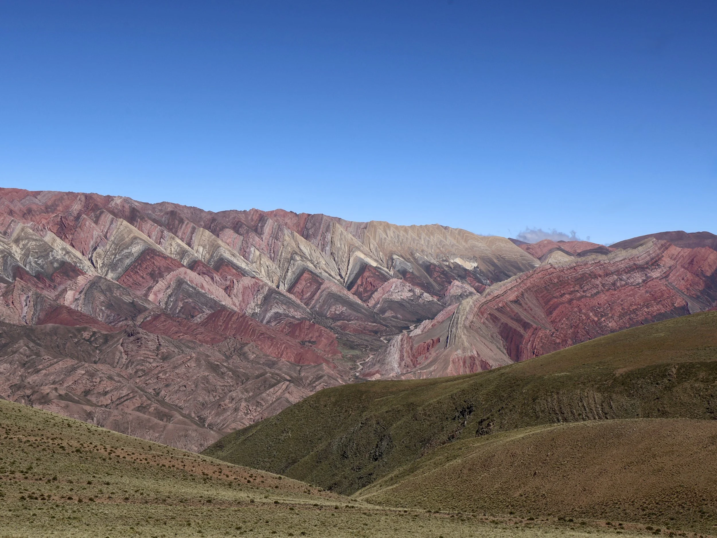
The Rio Grande valley is fairly narrow, with relatively high mountains on each side, which in itself would be enough to make the view picturesque. The vibrant, almost surreal contrasting colors, however, are what make these spectacular.
Intense, sustained tectonic activity shaped the Quebrada de Humahuaca. It lifted the Andes mountains and created faults and folds in the terrain. Mix in erosion and you’ll get this amazing, random mix of colorful layers of rocks, from green to purple to yellow to red, that gives the valley its distinctive look.
Distinctive doesn’t mean unique, and I would be reminded of this while visiting national and state parks in the Las Vegas basin a few weeks later, where the colorful mountains reminded me of some of the Quebrada landscapes. For how gorgeous was the Red Rock National Recreation Area, it doesn’t have the color variety of the Rio Grande valley, and it trades the river gorge scenery with ample wide plains.

The cactus-filled view over the Rio Grande valley from the Pucará de Tilcara.
We spent our afternoon walking in and around the village, and checked out the Pucará de Tilcara, the partially rebuilt remains of a pre-Hispanic fortified town. Situated on a hill with a wide view over the valley, its history is fascinating. It was initially erected by the Omaguaca tribe before being taken by the Incas in the 15th century, mere decades before the Spanish colonization, and the creation of present day Tilcara, closer to the river. You can visit some of the low stone houses and marvel at the beauty of the construction, while enjoying a stunning, cactus-filled view of the valley below.
On day two, I woke up early and, feeling like the sunrise could be a pretty moment to witness, had the idea to get out, unwashed, to check it out from outside our casita. The sun hadn’t risen yet, but the muted colors of the mountains on the other side of the valley were tantalizing. I imagined what it would look like when the sun would start touching them, a few minutes later.
Ahead of you, stands a mountain covered in jagged layers of colors so incredible, that you think you’re hallucinating.
Without thinking, I picked up the car keys and drove on a dirt road along the mountain, and got to an acceptable view point, where I eagerly waited for the sun. It was a spur-of-the-moment decision, and I quickly realized my night t-shirt wasn’t the most adapted outfit for the windy, 40° weather. The sunrise, though, made it worth the effort (and the shivering). All of a sudden, the mountains lit up, and the previously muted colors became vibrant mineral hues in almost all the shades of the rainbow. Watching the light rise on the mountain, second by second, minute by minute, was mesmerizing.
The best landscape of the day was to be something else, however, and, once showered and fed, we drove north towards our ultimate destination, El Hornocal or the Mountain of Fourteen Colors, the absolute highlight of this region for us, and certainly one of the most memorable sights of our three-week adventure.
Overseeing the hiking area in the Quebrada de las Señoritas.
Before reaching it, we wanted to check out a somewhat less famous attraction, the Quebrada de las Señoritas (Valley of the Ladies) and within it, the Red Canyon. Despite the claim of being less of a must-do, the hikes within this quebrada are labeled as a TripAdvisor Traveler Choice 2024.
The Quebrada is located off Uquia, a village that sits on the main road going through the Rio Grande valley. Uquia is a cute, blink-and-you’ll-miss it settlement that doesn’t have much going for it save a couple of small, unassuming restaurants and tourist stands, and the trailhead for the two hikes available in the Quebrada de las Señoritas start after about a mile on a sinuous dirt road.
A few cars were parked when we arrived, and we saw a tour van leave the site - never a good sign in my book, as I prefer my hikes off-the-beaten path. Both hikes require a guide, and, as of March 2025, the cost of entry to the site is ARS1,500 to park, and ARS6,000 per person to do the shorter hike (ARS8,000 for the longer one). We picked the short hike as both go through the Red Canyon, and we felt we may not have enough time to do the longer one. We saw most people elect this as well.
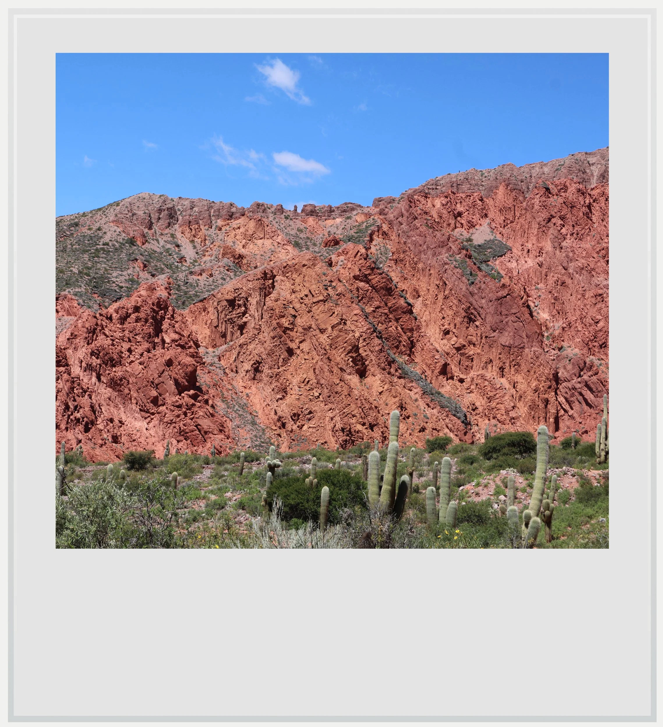
We were matched with a guide right away, and started walking among sparse vegetation, surrounded by glorious red mountains, of which I would be reminded a couple of months later, in the Valley of Fire state park, in Nevada.
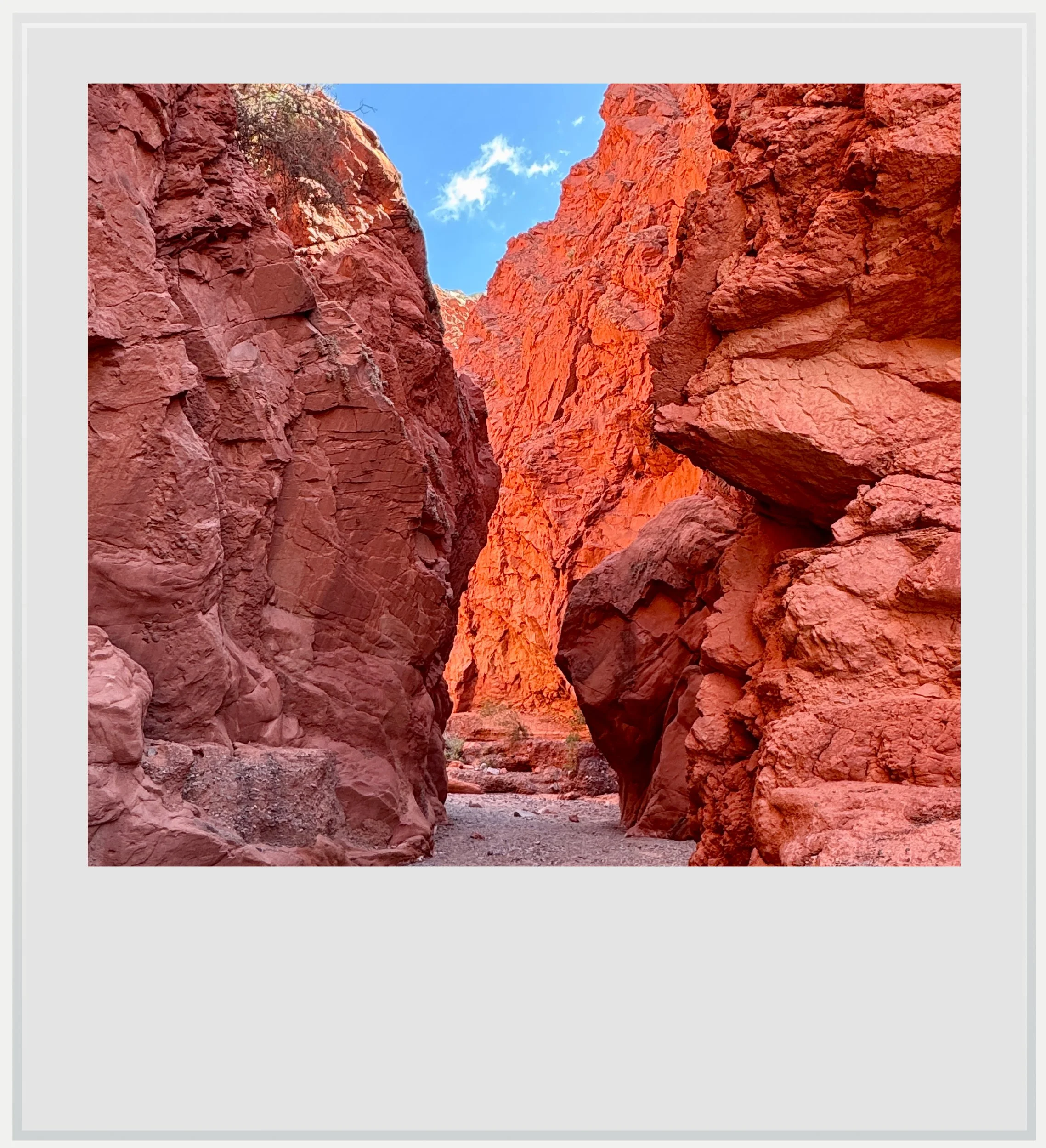
Inside the Red Canyon during our hike in the Quebrada de las Señoritas.
The highlight of the hike, however, was passing through the aptly-named Red Canyon. At times very narrow, it reminded my parents of Antelope Canyon in Arizona. Our group of seven people walked through the narrow gorge created by a water millions of years ago (water sometimes still flows in the gorge during the rainy season). The combination of the narrow mountain walls and the intense red hue of the rocks made us feel like we had reached another planet. Add to that the intensity of the silence (for all my fears, there were only a couple of groups with us on the hike, and virtually no one as we walked among the gorge), and this felt like a surreal experience.
We returned to the main road about an hour later, giving a ride to our guide on the way as he was heading back down. The tours in this Quebrada are managed by an association based in Uquia that helps locals take turns bringing the tourists in the gorge, so everyone gets an opportunity to make some money. Our guide was done for the day, and would go farming with his family in the afternoon. He suggested we check out one restaurant at our next stop, Humahuaca, and I am glad we did (it is listed below, in the Practical Information section).
Humahuaca was only a prelude to our visit of the Mountain of Fourteen Colors, but we had a pleasant stroll in the village. It is rather touristy and a base for many people wishing to go up to see El Hornocal. Unless you rent a car, your only way up is either via a tour bus or by riding with locals on massive 4x4 vehicles.
We were warned that the dirt road to get up to the view point for the mountain was treacherous, and many locals, eager to make a buck, tried to dissuade us from going up in our pocket car. I had also read horror stories of people getting stuck on the road. Yet, we persisted. In fact, the road is fairly safe, although winding and not paved. If you go slowly (which, given the lack of asphalt, is pretty much your only option), there is no reason why you would get stuck, stranded or worse.
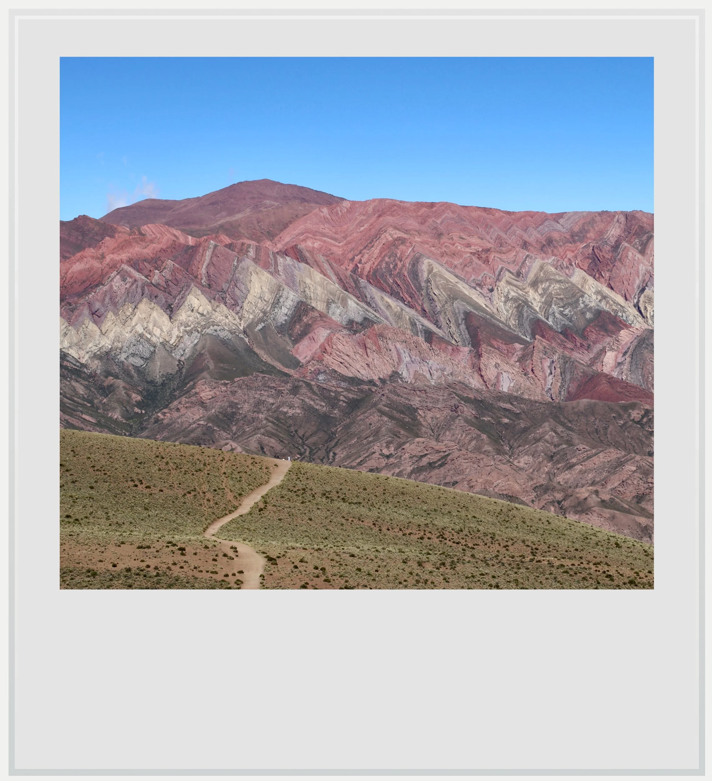
The Mountain of Fourteen Colors in all its glory, a few steps from the official viewpoint.
It took us almost an hour to get to the top, and we had to pay ARS1,000 to enter the viewpoint area, via another community checkpoint. The viewpoint itself sits at more than 14,000 feet (4,300m) and you’ll feel it as soon as you get off the car (don’t forget your sunscreen and drink copious amounts of water).
It’s hard to describe the view with words. Ahead of you, on the other side of another steep valley, stands a mountain that’s more than several miles wide, and covered in jagged layers of colors so different, so incredible, that at first you think you’re hallucinating.
How can this even be possible?
Is the altitude doing this to me?
Three reasons explain this natural wonder. First, the region was submerged under water millions of years ago, which led to the deposition of layer after layer of sediments over time. Then, these layers were folded and broken up by the violent collision of the Nazca and South American tectonic plates, which created the Andes mountain range in phases, starting about 200 millions of years ago. Finally, soil erosion has been slowly revealing the rocks colors.
The view literally took our breath away - although to be fair, the altitude played a role in that too - and the scenery is absolutely worth the trek. It was hard to leave and feel we would only remember this in our heads, something our eyes had trouble rationalizing.

Teenage llamas checking us out on the way back down from El Hornocal (fear not, the mother was nearby).
We went up in the afternoon, while most tour groups go up in the morning, when it is more likely that the mountain range will be in full view, without clouds. The later you can go the better, since the sun moves behind you as you look at the mountain, so the lower it gets, the lusher the hues will be.
From the viewpoint, there is a path that gets you slightly closer to the view (you will see people on it, it’s hard to miss). Do not hesitate to take it, as the closer you get, the more powerful El Hornocal seems. Just bear in mind the walk back to the viewpoint is quite steep, and with the altitude, it will take you a while.
The road to the salt flats can be considered worth the trip by itself.
We decided to take it slow on our third day, and only visited the town of Purmamarca, home to a smaller yet impressive Mountain of Seven Colors (I sense some valley rivalry). Purmamarca felt, to me, like the most developed little town in the valley. It probably helps that it is closer to Jujuy than Tilcara or Humahuaca, and sits on the road to the Salinas Grandes salt flats, another tourist hotspot.
Believed to mean “Town of the Virgin Land” although this is disputed, Purmamarca is a cute colonial village that has tremendously benefited from the increased attention to the region given by the UNESCO seal of approval. The town features a high concentration of high-end tourist shops but you can also find (delicious) empanadas cooked in front of you on the street.
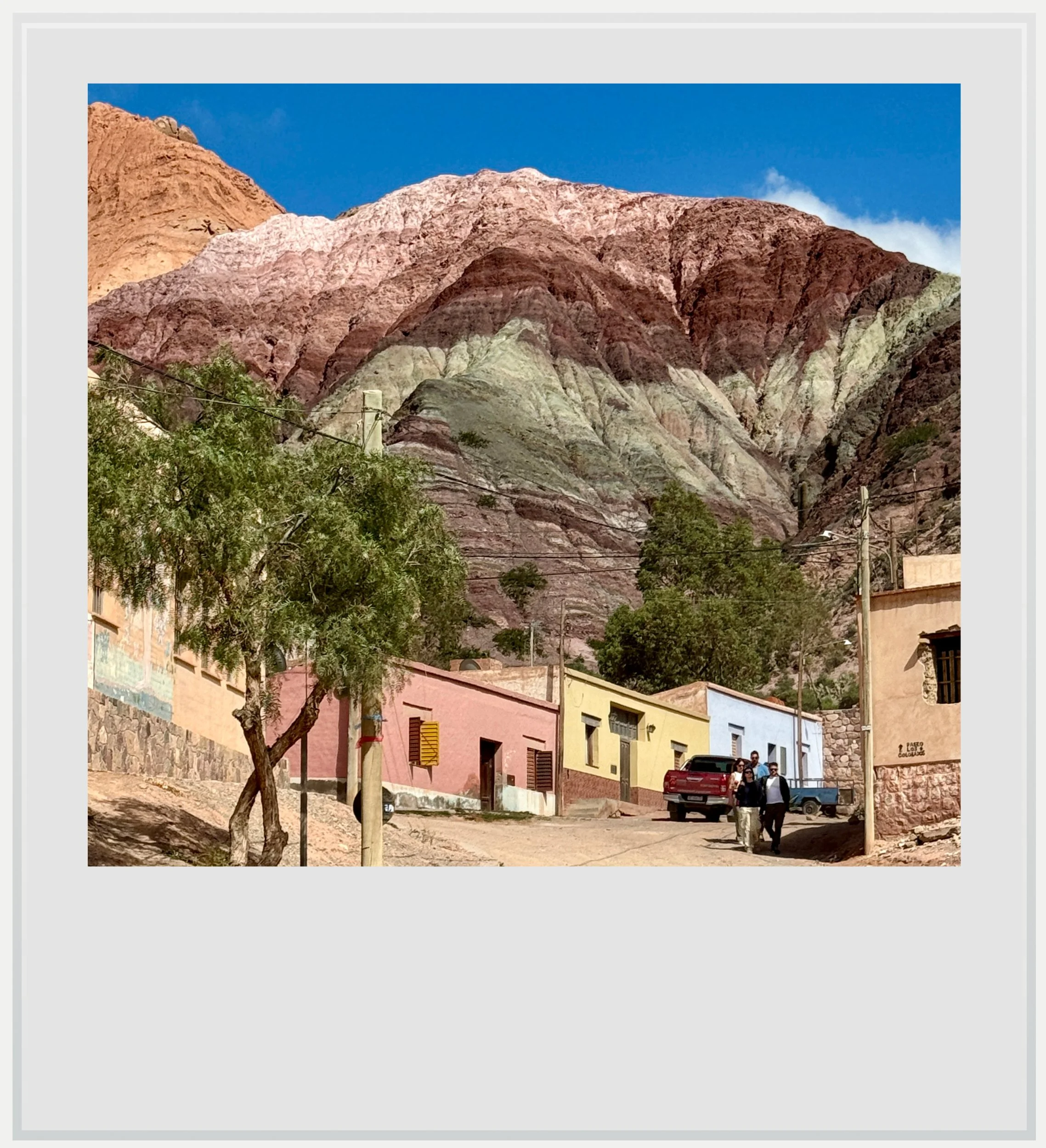
A street in Purmamarca with the Mountain of Seven Colors hovering behind it.
Purmamarca is most famous for its colorful mountain, a smaller rival to El Hornocal. You can visit it on a short, 45-minute loop hike for which you have to pay a nominal fee of ARS 1,500. The hike is easy and gives you a nice overview of the Quebrada de Purmamarca. The view over the colorful mountain that made the town famous is quite impressive, although, if I am being honest (and ready to make a stand on the touchy debate of “which colorful mountain is the best in the Quebrada”), it is less so than El Hornocal. It feels less massive, and the mountain is closer to you, making it less overwhelming to the senses. Its colors are somewhat more intense, however, which makes it a great sight (and, let’s be honest, it’s a lot easier to access).
Our final day in the region would see us take a flight to Buenos Aires from Jujuy’s airport in the evening, so we still had a full day to enjoy. We decided to visit the Salinas Grandes salt flats, to experience something very visually different from anything else we had seen in the area.
The road getting to the salt flats can be considered worth the trip by itself. It follows the Quebrada de Purmamarca then ascends the Lipán ridge on a steep road with more switchbacks than I could count, finally getting to the summit, at 13,681 ft (or 4,170 m) and offering a sprawling view over the other side, descending gradually towards the salars. It should take you almost two hours from Tilcara to get there.
Between five and ten million years ago, the valley where the salt flats sits was covered in water, which slowly evaporated, creating this stunning, immense area of whiteness, spanning 82 square miles.
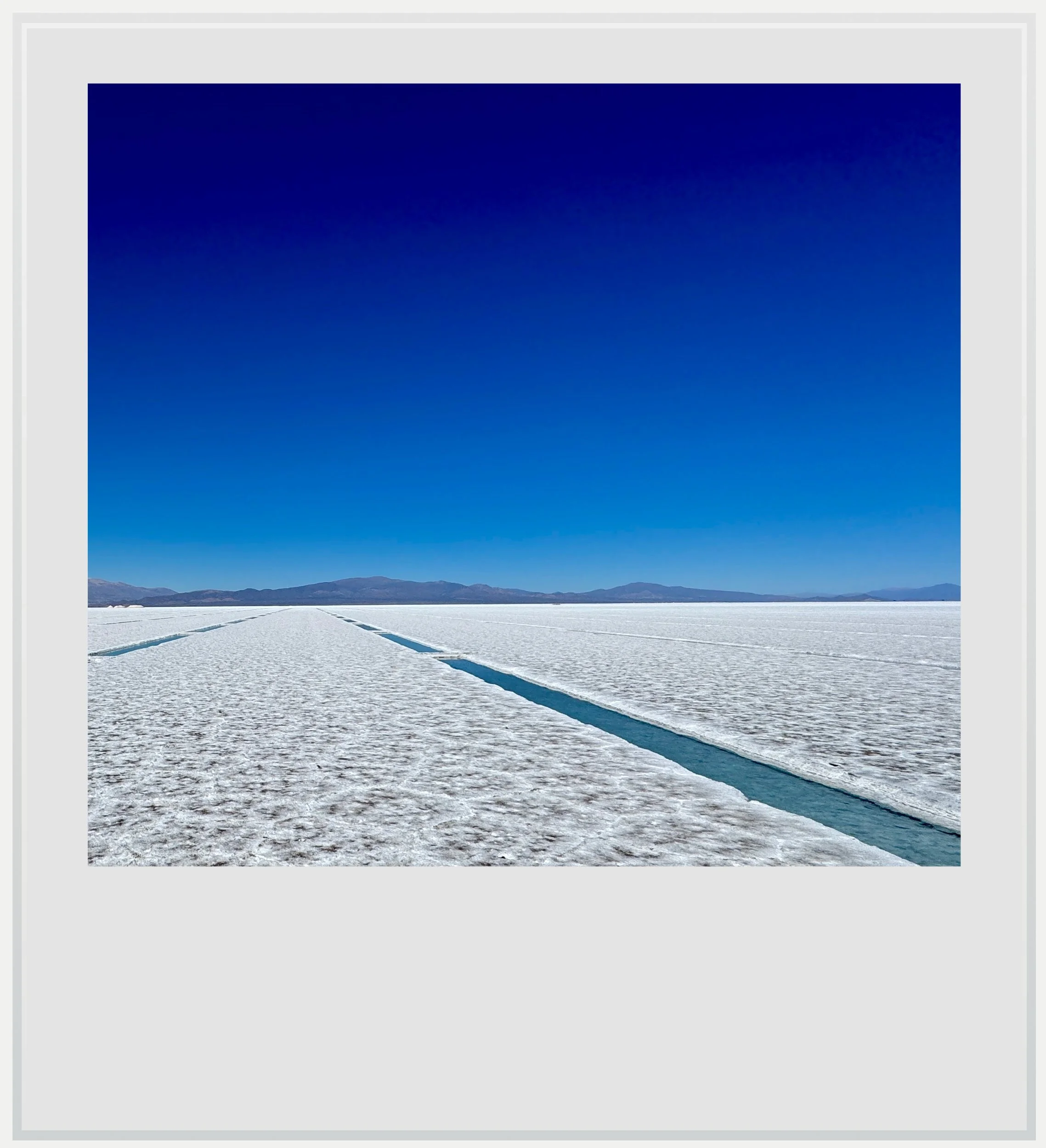
Alone on the Salinas Grandes salt flats.
We visited on a clear day, and the sun light made looking at the flats difficult, for how bright there were. A carefully framed photo could have made anyone believe we were walking in snow.
You can see most of the salt flats by staying in the two parking areas created for tourism to flourish, but I recommend to take a 45-minute guided tour of the salar, where you get to follow a guide in your car and get to a place of the flats where you’re completely surrounded by whiteness, away from the road and its traffic (and also away from the salt extraction activity, which you can see in the distance, as the flats are still being mined). The tour is book and paid directly on the first parking lot, in a house with tourism signage on its walls.
After our little roadtrip on the flats, we drove back south and ended up in Jujuy to catch our flight, capping a 4-day tour of an incredibly beautiful region of Argentina that still feels relatively undiscovered. If you’re planning a trip in Argentina, I would sincerely recommend you consider to add the Quebrada de Humahuaca to your itinerary.
Practical information (updated as of May 2025)
Getting to the Quebrada de Humahuaca and the surrounding area
The closest airport to the Rio Grande valley is Jujuy’s Gobernador Horacio Guzmán International Airport (IATA code: JUJ), about 90 minutes from Tilcara. Depending on flight schedules, Salta airport (SLA) can be a viable if further alternative (time to Tilcara: a little over 3 hours).
Jujuy airport is currently served by Aerolineas Argentinas from both Buenos Aires airport, Córdoba y Puerto Iguazú, by FlyBondi from Buenos Aires and by Paranair from Asunción, Paraguay.
Once at the airport, the best solution is to rent a car, unless you’re planning to base yourself in Jujuy or Salta for more than a few days, and can handle day trips to the Quebrada from there. If, like us, four days is all you have, traveling by car is easier and relatively affordable (although do read the advisory below).
I usually like to go by bus in Latin America when I am solo, because that is how most locals travel: it’s affordable, safe and buses run frequently. Because there were three of us on this trip, it felt easier to rent a car and visit at our own pace. That being said, many buses operate through the Quebrada and it is easy to reach all towns that way. You may have to book a local tour to get close to other attractions, like El Hornocal (the Moutain of Fourteen Colors) or the salt flats, but it can definitely be done.
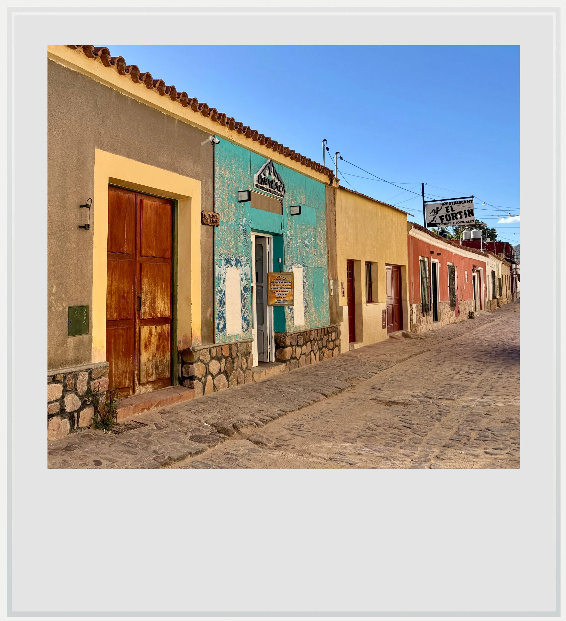
A street in the village of Humahuaca.
Renting a car
Ah, Argentina. The wide open spaces, the endless roads through fabulous landscapes… and some of the pushiest car rental agents I have ever met (although I think agencies in Costa Rica are worse, but that is for another post). Your biggest danger is really falling for insurance scams at the rental counter. Beware of the high franchise costs that may be presented to you then.
Most Western travelers usually rely on their credit card’s rental protection and decline the rental car’s CDW at the counter. Argentina isn’t a country where this is a problem, but of course rental companies make a lot of money on these, and will try as hard as possible to get you to buy some of their own guarantees. I almost got tricked by this in Salta. At the counter, the agent told me that if I were to decline their CDW, I would have to accept a pre-authorization of USD15,000 on my credit card, which was close of the full value of the car. First of all, many people don’t have such a big credit line, and second it makes you pause for a bit - what if something happens, and these dollars suddenly evaporate from my account? Of course, this is a scare tactic. It is extremely unlikely that you’re going to total a rental car in Argentina, and for a minor incident, the rental company will most likely charge you a much smaller amount, which your credit card coverage will eventually refund you. I knew of all this, and yet I hesitated. $15,000 is a lot of money. Just don’t fall for this, as I almost did.
Beyond that, roads in Argentina are well maintained, signs are plentiful, as are gas stations. I would only discourage you from driving in Buenos Aires, where it is claimed that a majority of dwellers share Italian ancestry. What they say about Italian drivers might be a cliche (after all I am French, and can tell you the Parisian drivers are in a league of their own), but I can’t help but correlate that with the sheer madness of motorists in the Argentinian capital. Besides, you really don’t need to get a car when public transport infrastructure is top-notch, safe and very affordable - also, Ubers are plentiful.
Safety
The US State Department labels Argentina as a level 1 country, meaning “Exercise normal precautions” when you travel. In fact, Argentina as a whole is extremely safe, even if the country’s economic situation has resulted in more precarious living for the poorest portion of the population in the past years. Strikes are possible, and demonstrations are common around the Casa Rosada, the presidential palace, in Buenos Aires.

Sunrise over the Quebrada de Humahuaca, from the outskirts of Tilcara, looking towards the south.
Food
We didn’t eat out a lot during this portion of the trip. We did however appreciate two restaurants that I wanted to highlight:
Tilcara: La Picadita (GoogleMaps link). A cute restaurant set up in several small rooms and a patio with great cuisine (the trout was delicious) and great service. It is close to the main square and not far from another restaurant we wanted to check out but didn’t, Bien Me Sabe.
Humahuaca: La Tuna (GMaps link). This one was recommended by our tour guide in the Quebrada de las Señoritas, and I couldn’t thank him enough. While the restaurant itself is nice but won’t win any design awards, the food is incredible, and catered toward local tastes. I tried the estofado de llama (llama stew) which was unlike anything I had tried before. Service was a little slow, but the food more than made up for it. Oh, and also, free wifi.
All images are mine and copyrighted. Reproduction is strictly forbidden.
Each image’s legend will appear if you hover over them (on a computer) or click on them (on a mobile device).