Dzibanche & Kinichna, Mexico.

Two Southern Yucatan Maya settlements home to the powerful Kaan dynasty.
Looking for concrete details and tips? Go straight to the Practical Information section.
It was past 11am when I got into the car park for the visitor center to the Dzibanche and Kinichna Maya sites. Like every other site in the region, the buildings had been recently built and freshly painted. It only reopened in February 2025. It was a welcome side effect of the investments made by the previous Mexican government into the development of the region, whose most obvious sign was the Maya Train.
Unlike other archeological zones, and perhaps because this one was scattered in four main sites, the visitor center was disconnected from the two biggest settlements: Dzibanche and Kinichna. Instead, it abutted Tutil, a more recently explored complex. After paying the entry fee, I drove my car less than a mile, and got to the small, shaded parking lot for Dzibanché.
As would be the case for almost all of my visits, I was the only one on the site. There were no other cars there. It was a welcome difference from sites in northern Yucatan, even less famous ones like Dzibilchaltun, near Merida. It felt eerie to discover these ancient sites all alone, undisturbed, almost undiscovered.
Dzibanche was indeed re-discovered in 1927 by British-Irish explorer Thomas Gann, who gave it the name it still bears today. Meaning “writing on wood”, Dzibanche was christened as such owing to the discovery of sculpted lintels within one of its temple.
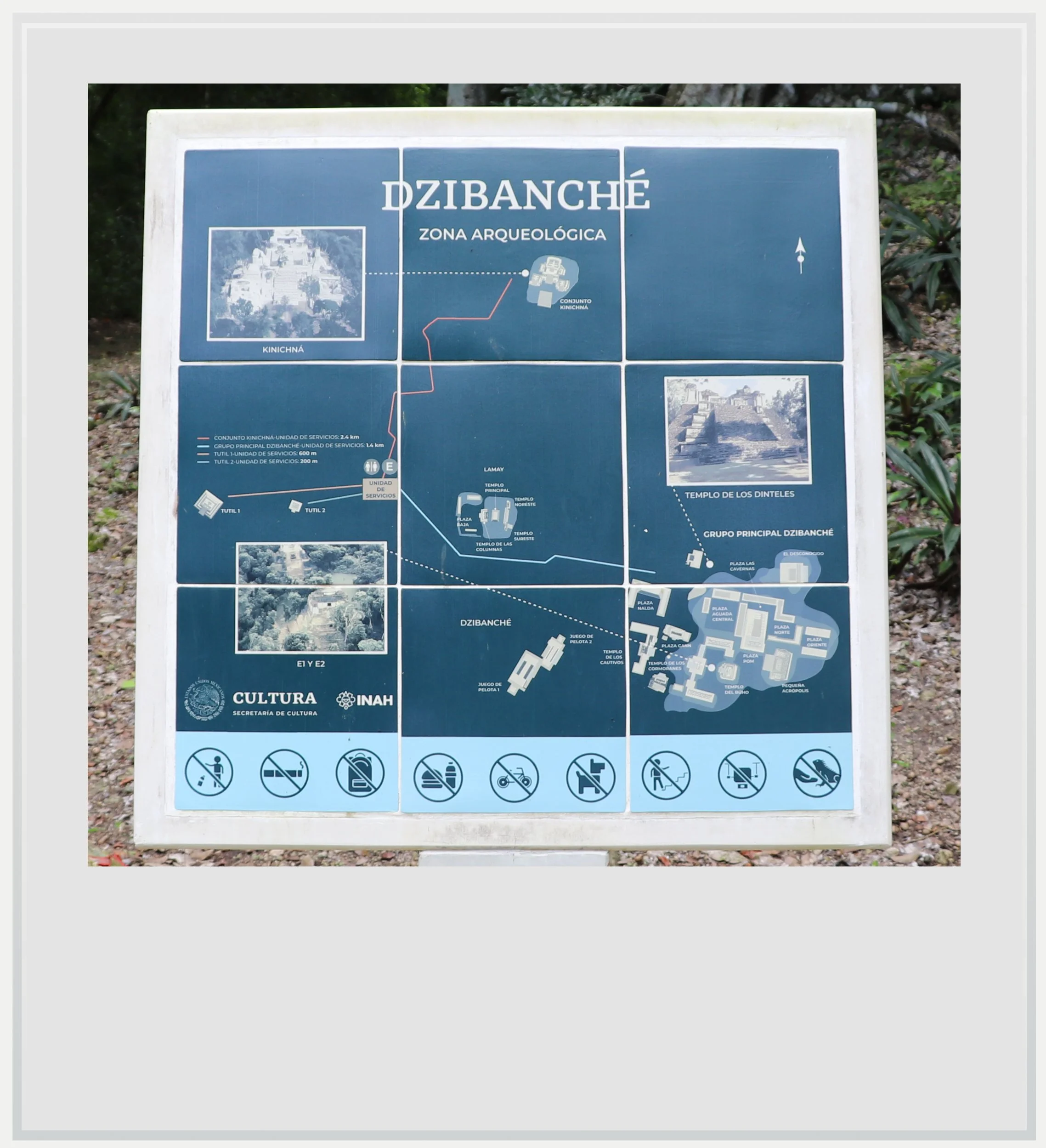
The map of the Dzibanché Maya settlement.
It is believed that Dzibanche was named Kaanu’l, or place of snakes, in the Mesoamerican era, and its main ruling dynasty was known as the Kaan, or the Snake kings. Dzibanche was first built around 300 BC and gradually became the most powerful city of the southern Yucatan lowlands, ruling over a wide portion of territory spanning parts of Mexico, Belize and Guatemala. In the middle of the 7th century, the Kaan dynasty decided to move its capital to Calakmul, to the west.
The immense power amassed by the Kaan dynasty explains the grandeur of Dzibanche and its surrounding areas (the settlement also encompasses Kinichna, Lamay and Tutil and is only about 14 miles from the nearby ancient Maya city of Ichkabal as the crow flies). Somehow, the site didn’t feel as imposing, probably because most of it has yet to be excavated, and the ruins are surrounded by lush vegetation, hiding their true size (unlike, say, Chichen Itza). It felt strangely intimate to walk among the buildings on my own.
I wasn’t alone for long, however. Like many more recent Maya sites that have been open to the public but remain partially undiscovered, guards were patrolling the complex, and a relatively friendly one shadowed me for most of my visit. It was actually super helpful to chat with someone who, although not a guide by any means, knew his way around the area, and could point spider monkeys, up in the trees, that I would have missed on my own.
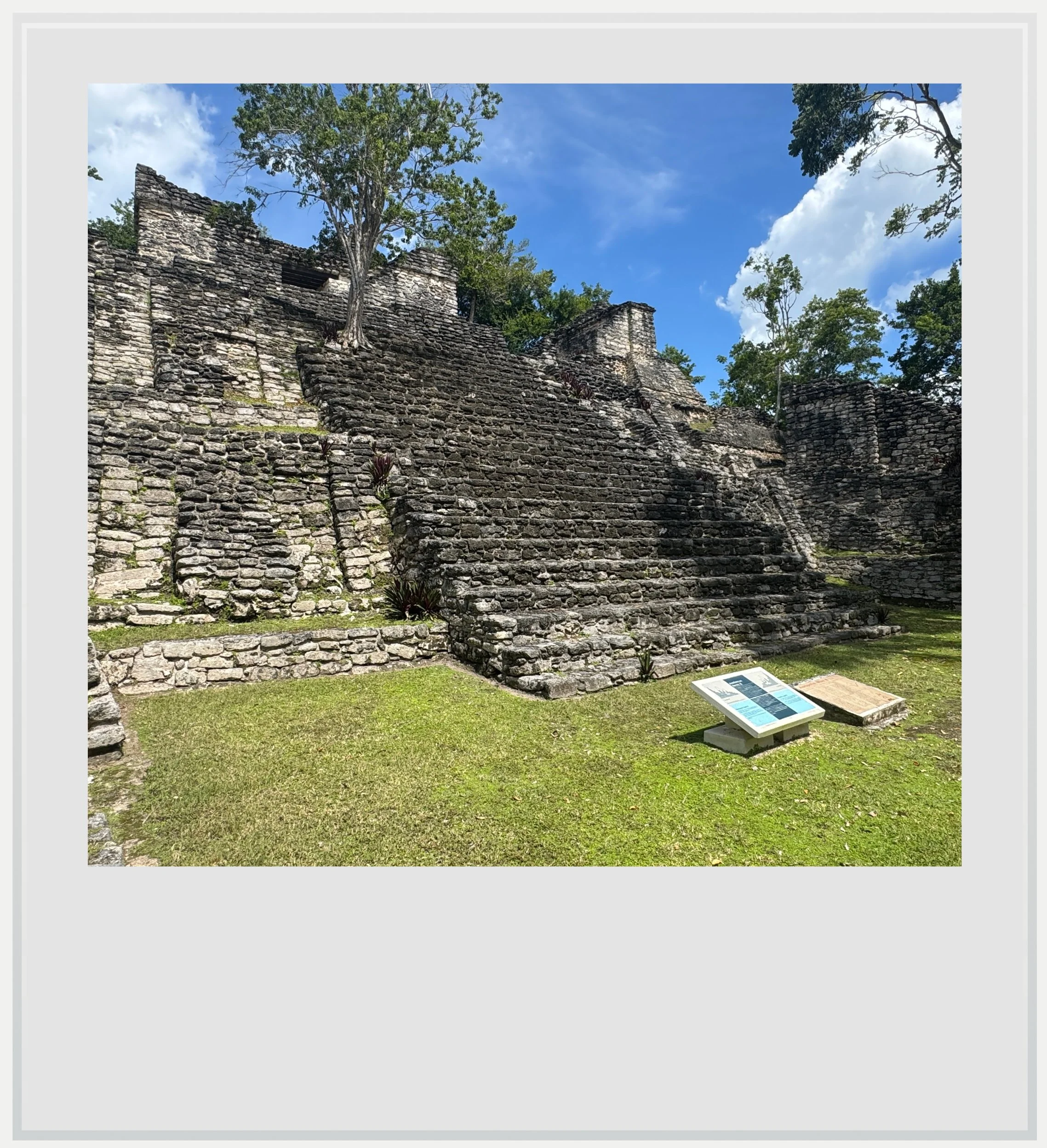
The two most notable buildings in Dzibanche are the Palace of Lintels (Palacio de los Dinteles) and the Cormorants’ Temple (Templo de los Cormoranes).

Palacio de los Dinteles in Dzibanche.
The "Palace of the Lintels”, also known as Temple VI (or Edificio 6), was named by Thomas Gann in 1927 when he found carved wooden lintels with hieroglyphic inscriptions that had stood the test of time (the lintels are no longer on site for preservation purposes).
The temple stands on a stepped pyramid with three levels. The pyramid's base was built according to an architectural style known as talud-tablero (“slope and panel.”) This style, which involves a platform structure built on an inward-sloping surface, was influenced by design seen in the central Mexican city of Teotihuacán, close to modern day Mexico City.
The lone worker told us he was always on the move to prevent a jaguar attack.
The pyramid portion was built during the Early Classic period (200–600 A.D.), while the temple at the top was a later addition from the 6th century A.D.
The Temple of the Cormorants, or Temple II (Edificio 2), is a prominent funerary temple on Xibalba Plaza. It is the tallest structure in the settlement, with a height of 112 feet (34 meters). It consists of a large, stepped pyramid base. It was built during the 6th century A.D., when Dzibanche was the capital of the powerful Kaan dynasty.

Palacio de los Cormorantes in Dzibanche.
What makes this building extra special are the intricately sculpted stucco friezes that were originally covered in red paint (which are currently being restored, and you can see some of the restoration work on the left side of the pyramid). They are protected by a thatched roof for conservation, and it’s a stunning reminder that the pyramids we see today looked nothing like this in ancient Maya times, as they used various techniques to paint them in different colors.
The base of the Temple of the Cormorants served as a royal burial site for members of the Kaan dynasty, the most famous of which being Ut Chan, who reigned in the 6th century.
Another highlight for me was Plaza Pom. Dzibanche was about the 8th Maya site I visited on my trip, and while they all had something unique about them, there was always a sense of grandeur, meant to impress, just like brutalist architecture was created to make men feel very small in front of a higher authority (in most cases, the state). It was hard not to feel humble among these huge, ancient buildings. Plaza Pom, by contrast, was a smaller space, made even more intimate by the encroaching vegetation. It felt like the small square you’re surprised to discover in the middle of a busy city, a place that was even quieter than the rest of the site. During Maya times, it is believed that its access was restricted to the settlement’s ruling class. Try to spend a few minutes taking it in when you visit Dzibanche.
I went back to my car and drove back to the visitor center, where another road to the right led, in minutes, to a second site, Kinichna (“House of the Sun God” in modern Maya). While Kinichna only counts with one major building, the Acropolis (also known as Casa del Sol or “House of the Sun”, it is actually a massive, three-tiered pyramid that evolved through multiple construction phases. Used as a burial place for members of the Kaan dynasty, it is believed this was one of the first buildings erected in the Dzibanche area, thanks to its nearby water source.
The Kinichna pyramid near Dzibanche, Quintana Roo, Mexico.
Kinichna’s role within the settlement was strongest during the Early Classic Period (250-450 AD).
As for many sites in southern Yucatan, it is possible to climb on top the House of the Sun, and I recommend you try, being careful about the irregular height of the steps and the fact they can get slippery, to enjoy a panoramic view over the region. It was well worth the effort.
It was time to head back to the visitor center. The nice lady at the counter had mentioned there was a third site I could visit, called Tutil. In fact, the path to get there started right behind the visitor center’s main building. The path is protected by a gate and security guard quickly came to join me on my tour. I quickly understood why. While two pyramids have been excavated at Tutil, work is still being done on the second one, and there are more than forty structures yet to be unearthed. They are quite easy to spot in the forest (any mound you see is probably going to reveal a pyramid underneath it).
That part of the site was even quieter than the other two, and the vegetation was more dense - to the point that the lone worker cleaning some steps of the second pyramid told us he was always on the move, to prevent a jaguar attack (he was pretty scared that, should he stop moving to rest or take a nap, one would come out of the jungle and hurt him). Jaguar attacks are extremely rare in the area, but the security guard confirmed he had heard a few of them over the past few years. That made me want to come back pretty quickly to the parking lot, thankfully without any jaguar in sight.
The Tutil site is fascinating as you can literally see the archeological work being done in front of you. As such, it is very much a work-in-progress, but it’s incredible to imagine what secrets are still kept by all the structures yet to be discovered.

Tutil 1 building in the Dzibanché archeological zone.
I had a little more time in my day for another Maya site, Kohunlich, located about 45 minutes to the south. I passed by Morocoy, the only village on the way, and stopped at an abarrote, a small grocery store, selling soft drinks and snacks. I wished I had brought more food with me, but the pan dulce I bought tasted heavenly.
A few minutes later, I was back on highway 186 for a few miles, before turning on to the road leading to Kohunlich.

What stayed with me
I visited many Maya sites this year and in previous ones, and was always impressed - and humbled - by the sheer size of their buildings, in Palenque, Calakmul, but also in smaller sites like el Hormiguero, in the neighboring state of Campeche. I definitely witnessed these impressive structures in Dzibanche and Kinichna. However, what I liked the most on was the more intimate Plaza Pom. Secluded, almost intimate, it provided a different insight into the Maya people living there. I sat, contemplative, for a few minutes, feeling that this was a place not to gaze in awe, not to bow your head in respect, but just a place to live an -almost- normal life for the times (bearing in mind the plaza was most likely reserved for the elite). It was both unexpected and welcome, a sign that beyond the huge pyramids and temples, there is much more we yet don’t know about this civilization.
Practical information
(every question you could possibly have, answered - updated as of March 2026)
In a nutshell
Dzibanche and Kinichna are technically two different sites for the Mexican National Institute of History and Anthropology (INAH), but they are so close to each other that there is only one visitor center for both of them, where you will have to stop to get tickets.
Entrance fee: MXN 80 per person plus MXN60 per person and MXN50 per car as a community contribution to be paid in cash right after the turn off to Dzibanche (after passing the village of Morocoy).
Opening hours: 8am to 5pm (last entry to the sites at 4.30pm)
Visit should last 45-60 minutes in Dzibanche, and about 20-30 minutes in Kinichna. Add another 20-30 minutes checking out the Tutil zone as well.
Travel time by car: from Chetumal 75mn, Bacalar 75mn, Xpujil, 75mn.
Make it a full day trip by adding the Kohunlinch Maya site to your itinerary. Kohunlich lies about 40mn south of Dzibanche. From Kohunlich, Chetumal and Bacalar are 1h away, and Xpujil 50mn away.
Getting to Dzibanche and Kinichna
Dzibanche and Kinichna, although designated as two different archeological zones, are historically part of the broader Dzibanche Maya site, and are just a couple of miles apart. As such, it makes sense to consider them as one destination on your itinerary.
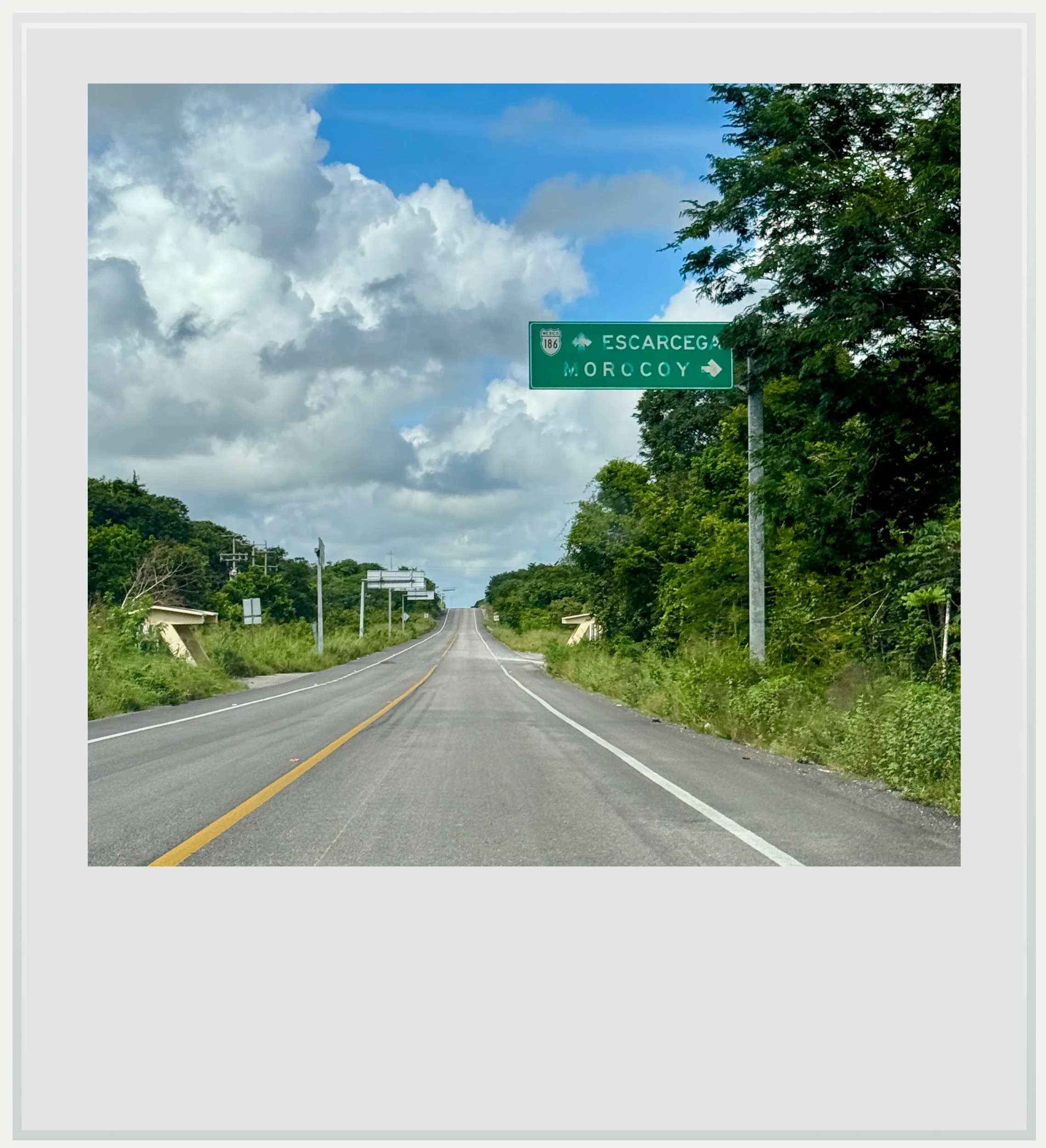
From Bacalar or Chetumal, head west on highway 186 until you see the turn off for Morocoy (see image above), cross Morocoy, then turn right at the Dzibanche/Kinichna sign (picture below). You’ll have to stop and pay a community fee of MXN60 per person and MXN50 per car, and will get to the visitor center a few minutes later. You have to get your tickets there before going to either Dzibanche or Kinichna.
How to get to Dzibanche and Kinichna from the United States: the Maya sites are located in southern Quintana Roo, Mexico, about 1h15 from either Chetumal or Bacalar. Assuming you’re not planning a weekend trip from the US to Dzibanche (which I don’t recommend), the sites will be part of a broader Yucatan itinerary. The closest airport to Dzibanche and Kinichna is Chetumal (CTM) . It has no direct flights to and from the US, making a connection in Mexico City (MEX) indispensable. Assuming Dzibanche is one stop in your Mexican itinerary, a rental car is most appropriate and can be picked up at the Chetumal airport. Getting to archeological zones can be done easily with an organized tour, and most leave from either Chetumal or nearby Bacalar, but any other mode of transportation will be complicated (regular buses do not serve the archeological zones, and a taxi, unless rented for the day, may not make sense).
Another option could be to fly into Tulum (TQO), if planning a trip spanning more of the Yucatán peninsula, as US and Canadian airlines fly non-stop to the new Tulum airport, but travel time from TQO to Dzibanché is close to three and a half hours. This option works more easily with a rental car, and makes sense if you’re planning to make your way to Bacalar or Chetumal before getting to Dzibanché.
How to get to Dzibanche and Kinichna from Mexico City: the best way to reach Dzibanché is to fly into Chetumal airport (CTM), from Mexico City’s main airport (MEX) or its secondary airport (NLU). Aeromexico, VivaAerobus and Volaris operate once a day between MEX and CTM while Mexicana and Viva fly several days a week from NLU to CTM, with base prices starting around USD75. Car rentals are widely available at Chetumal airport, from a variety of Mexican and international companies. Dzibanche is 1h20 away on a well-maintained highway. As mentioned above, you other bet is to book a tour from Chetumal or Bacalar if you’re based there, but no colectivos or regular bus service will drop you at the ruins.

How much does it cost to visit Dzibanche and Kinichna
The entrance fee for both archeological zones is MXN 80 per person. You’ll need to add MXN60 per person and MXN50 per car as a community fee (cash only), to be paid right after the turn off to Dzibanche and Kinichna, past Morocoy (see picture just above this paragraph).
When to go to Dzibanche and Kinichna
The best months weather-wise to enjoy the southern Yucatan region as a whole are during the dry season, between December and April, with January and February the (relatively) coolest months. This is also peak season so the sites may be a little crowded, but this is all relative. There were only 3 visitors in the guest register at Dzibanche and Kinichna for the day before my visit and, arriving just before noon, I was the first for the day. I don’t imagine there will be a line to get in during the winter months either.
I traveled to southern Yucatan in October, which is low season, as the combination of possible afternoon showers and intense heat can turn off travelers. I loved the lack of crowds, and the slightly overcast weather which made the heat more tolerable. Yes, it rained almost every day around 5pm for a few minutes to a few hours, but it was all pretty manageable.
Safety in Dzibanche and Kinichna
The Yucatan peninsula is one of the safest areas in Mexico, and Quintana Roo is considered fairly safe: it is labeled a level 2 “Exercise Increased Caution” state, just like Mexico City, or the UK as a whole. Digging deeper, busy cities like Cancun are more likely to be where crime happens, and the advisory shouldn’t, in theory, apply to the sleepy southern region. As such, it is not an area of Mexico where you would have to be a fairly experienced traveler to feel safe. As everywhere else in the country, keep in mind the following: know where you’re going, keep your wits about you, do not flash expensive clothes or phones, don’t do things you shouldn’t do, stay in touristy areas, avoid walking at night.

The ticketing building in the Dzibanché-Kinichná Visitor Center.
Food & lodging in Dzibanche and Kinichna
Hotels
There is no hotel near the site. The closest one is the rather fancy Explorean Kohunlich, close to the eponymous archeological zone, about 20 miles (32km) away.
Your best accommodation bets will be to the east in Chetumal or Bacalar (about 1h20 away) or Xpujil, 1h15 to the east in nearby Campeche state, which could make sense if you’re planning to visit other sites like Becan or El Hormiguero.
Restaurants
There is no food available in Dzibanche or Kinichna. Bring your own or stop in the closest town, Morocoy, where a few small abarrotes on the main road will sell you cold drinks and snacks to tie you over. Don’t expect fancy ciabatta sandwiches or Fiji water, though. Again, you’ll find most restaurant offerings in Chetumal or Bacalar to the east, and Xpujil to the west.

A spider monkey about to jump from a high branch within the Dzibanché Maya settlement.
Keep in mind these travel tips
The Yucatan peninsula is one of the safest regions in Mexico, and its main roads are well maintained. This isn’t enough to forget the #1 driving advice in Mexico: do not drive at night. Driving at night, on poorly lit roads means you won’t see the motorcycles without lights, the potholes and the ubiquitous topes, these notoriously hard speed bumps that seem to spring out of nowhere. You may encounter wildlife or, more prosaically, street dogs crossing right in front of you (especially in Bacalar, where there are many). Plan your itinerary to be at your next destination before night fall. It’s important.
No matter the season, there will be bugs in Yucatan. While you may only see the gigantic Tarantula yucateca spider on the roads leading to Calakmul, you’ll find mosquitoes pretty much everywhere, and especially in the shaded forests surrounding the Maya ruins. Be ready with repellent at any time of the day. It’s also a good idea to wear clothes that cover your limbs (pants, high socks, long sleeve t-shirts) while you’re in the jungle. Mosquito-borne diseases are fairly uncommon in the state of Quintana Roo, but not unheard of.
SPF will be your best friend. The UV index may be low in the morning and evening, but during the day, it gets pretty high.
Do not forget to hydrate. While OXXOs aren’t as ubiquitous in this rural region as in other ones, you’ll find plenty of abarrotes, these tiny stores selling cold water and sodas along the way. Make sure you always have water handy and drink to make the heat more bearable.
Cell service isn’t the best near Dzibanche, although Telcel offers 4G coverage on the main highway, 25 minutes away (and, for the record, I was able to get Telcel service at the top of the Kinichna pyramid, enough to send and receive a few pictures). Telcel is actually the only provider with decent service in the broader region. If you’re roaming, check that you can roam on Telcel, or investigate a Mexican eSIM that uses this network. If not, think about downloading maps for offline use, it may prove very useful.
Any questions I may not have thought about? Do not hesitate to drop me a line!
Every photo caption appears if you hover over it (on a computer) or click on it (on a smartphone).
All photos are mine and copyrighted.