Brive to Aurillac by train, France

From Corrèze to Cantal on a rural rail line whose future is uncertain.
It was past noon when I finally got on the express train service from Paris to Toulouse which was to pick me up in Limoges and drop me off in Brive about an hour later. It wasn’t the train I was supposed to take, but my earlier TER train to Brive had been canceled for lack of personnel, and I had to wait a little longer in Limoges to get to the official first stop of this trip, Brive-la-Gaillarde.
I had actually started my voyage earlier in the day in Poitiers, where I boarded a tiny, slow but clean regional train to Limoges. We traveled at sluggish speed towards the Limousin region, leaving behind us field after field of lush green – this was early June, after all, and spring was out in full force. The Poitiers to Limoges service uses a single-track line, and midway, in Le Dorat, trains going north and south wait for each other so each can go on their merry way. That day, in a testament to the French railways’ dedication to timeliness, both trains glided into the station at the same time, like a well-rehearsed ballet. A minute later, we were moving again, on a now-clear track.
Both trains glided into the station at the same time, like a well-rehearsed ballet.
I had invested in a European rail pass for this trip, and was aiming to avoid paying any supplement (SNCF, as French railways are officially called, is known for slapping an additional fare on basically any train that isn’t a slow regional service) and as my Limoges-to-Brive train got canceled, I realized I would have to pony up an additional $10 to get onto the express service instead. There was little to gain by arguing with the (otherwise friendly) lady behind the counter at the Limoges-Bénédictins station – a stunning work of 19th-century architecture, which made me want to come back to Limoges to visit and write about it someday.
These $10 didn’t get me much more than a slightly faster trip to Brive. The French railways use cars that are way past their prime on this route – most of the traffic between Paris and Toulouse is funneled through high-speed TGV services that use dedicated high-speed lines via Bordeaux. As a result, this Paris-to-Toulouse service felt like an unwanted child, from the state of the outside paint to the cleanliness of the seats. The train was full, however, with many people coming off with me in Brive. Trains like these are a lifeline for the small cities that dot its route, as they are not well linked to the French highway system, and have very little air service.

Arriving in Brive was a little bit of a letdown. The town used to be a very big railway stop, at the center of what the French call an étoile ferroviaire, basically a train hub, and while the sheer number of platforms was impressive, the actual station itself was tiny, almost unbecoming for such a big junction. Brive is still a hub, and trains go in several directions, from Paris and Toulouse to Bordeaux, Périgueux, Tulle or Aurillac, but their numbers have dwindled over the years.
I chose to spend a few nights in Brive as the first official stop of this trip through central France. I wanted to only use public transport from beginning to end, and let the relative randomness of SNCF routes drive the itinerary. After Brive, I would head towards Aurillac, and then on to Figeac, Rodez and Toulouse before heading back towards Poitiers.
I wanted to let the relative randomness of SNCF routes drive the itinerary.
Brive-la-Gaillarde, a city of about 45,000 people, the biggest in the Corrèze department of France, was one of the earliest passage points over the Corrèze River. Its Gallic name, Briva, from an earlier Indo-European word bhrewa, literally means a plank placed over a river to cross it. Back then, Brive was a stop on the road between Lyon and Bordeaux.
“Gaillarde” was added later. Unlike what a lot of French people think, it has nothing to do with being a big, strong woman (the current French meaning of “gaillarde”). Instead, it refers to old French and means “fortified”, as in protected by walls. Brive was indeed fortified in the 14th century as a way to defend itself better against the British, who owned part of France back then.

The town gained most of its stunning architecture in the 18th century, and in parts of the historic core, you could be forgiven for thinking you’re in Haussmannian Paris. Its economy flourished in the 19th century, when it became a stop of the train route between Paris and Toulouse and later a hub with six spokes radiating in as many directions.
Walking from the station to the town’s center is a lesson in architecture and history. The train station’s location was outside of what was then the urbanized area, like in most French towns. As one walks down on Avenue Jean Jaurès towards the town’s center, you’re led to what looks like a ring road, beyond which you see tiny, curving streets and alleys. This ring road is where Brive’s walls used to be. They were dismantled in the 18th century to create the road that circles its center, along which beautiful mansions, still standing, were built.
You can spend half a day marveling at the casualness with which French people enjoy beauty.
Once you get into that center, everything changes. The town has invested a lot to beautify its core and it shows. There were very few cars, and most of the streets were set up to favor pedestrians and bikers. This core is a mix of narrow streets from the Middle Ages with barely enough space for a car to pass – you can almost touch the walls on each side with both your arms extended - and a few larger squares created in the 18th century, surrounded with palatial mansions that remind you this used to be a very wealthy town. Although Brive’s historic core isn’t huge, you can spend half a day walking through every street and marveling at the casualness with which French people enjoy beauty. Everything, from the chairs on the street to the signs on the doors felt like it effortlessly came straight out of a cool design magazine. I have visited many French cities and rarely have I seen such consistent expression of unassuming, designed beauty.
Walking in Brive’s center, as a result, feels like a delight for the senses and yet one wonders to what extent this is real or just cleverly marketed for tourists to show how a nice, bourgeois French town should look. Is that cute chocolate store one that is serving locals, or is it just there to validate the feelings of authenticity tourists are expected to seek?

Striking the balance between a livable city for locals and Instagrammable sights for the unsuspecting tourist is hard, and I am not implying Brive isn’t doing it right – if anything the city is incredibly beautiful, and very well preserved. I couldn’t shake off the feeling, however, that this historic center was really a beautiful display for tourists.
I had chosen to make this train trip through central France now, while I still could. Some of the rail lines that cross the heart of the country are in danger of being downgraded, with commercial train service eliminated. Back in 2019, local newspapers reported trains between Brive and Aurillac may stop running in 2021 because of lack of investments in the track. Financing was found and the line is still running, but its future is uncertain beyond the next few years, and serious cuts in France’s budget could mean the end for this line or other rural ones. I felt this was a trip I had to do sooner rather than later.
The early morning light made the surrounding hills glow a beautiful sunny yellow.
After two days in Brive, my next stop was Collonges-la-Rouge. The only way to get to Collonges from Brive on public transport was by taking an early bus, actually the only one of the day. French departments finance a dense bus network that is roughly equivalent to the US school bus system. In fact, all of the 18 passengers of my bus to Collonges-la-Rouge were teenagers headed for school. The driver confided that before me, the last tourist he drove to Collonges was a British woman, about two weeks earlier. It felt somewhat reassuring I wasn’t the only crazy person getting to Collonges via public transport.
The bus stopped many times along the sinuous county road while the early morning light made the surrounding hills glow a beautiful sunny yellow. The driver would greet every single student boarding the bus by name. It felt less like a bus trip and more like a family voyage, picking up relatives along the way.

Arriving in Collonges in time to drop students at school meant I had the village almost to myself. While mostly unknown in America, Collonges is quite famous in France as the first village to be awarded the official title of “un des plus beaux villages de France”, one of the most beautiful French villages, a source of pride for any town which receives it. The bus driver told me tour buses would start arriving around 10am. I had about ninety minutes to truly explore on my own.
Collonges-la-Rouge is striking for its incredible architecture and visual unity. All the buildings in the village are built with red sandstone from a nearby quarry, popping against the lush green of the surrounding fields and forests. It is an extremely well-preserved entity and walking through the narrow streets gave me the same feelings I got in Dubrovnik, where you feel you stepped back 500 years ago. It is quite something.
Before becoming a symbol of French preservation, Collonges went through several ups and downs.
Collonges was founded in the 8th century, and before becoming a symbol of French preservation, went through several ups and downs. Prosperous in the Middle Ages because of its location on one of the Caminos de Santiago, the village was fairly damaged during the French Revolution, which caused a massive population exodus. Collonges then became a literal open-air quarry. The first conservation efforts started at the beginning of the 20th century and the town became an official historical site in 1942. Further conservation efforts took place in the 1970s to remove signs of modernity like overhead lines, and the village eventually passed a law preventing cars from entering its core during the tourist season.
Visiting Collonges early in the morning, before tourists come in, was a very enjoyable experience. Walking its cobblestone streets with no car in sight, except a compact delivery truck here and there, brought a sense of quiet serenity that stayed with me for a while.

There was one thing though. I felt tourism, while keeping Collonges alive, had destroyed a little bit of its soul. Throughout my walk, I could hardly see any shop or restaurant that didn’t feel like it was geared towards tourists. The village was full of hotels, restaurants and bed-and-breakfasts, but nowhere did I see a semblance of normal French village life, the expected bar-tabac or the bustling bakery.
Meyssac, a slightly bigger village about a mile south, similarly built with red sandstone, felt much more authentic if a bit less photogenic, and that’s where I decided to spend a little time before heading back.
It doesn’t take anything from the incredible beauty of Collonges-la-Rouge, but the museumification of the town made it feel a little superficial – as if all of what makes a village come to life, the noise, the locals going by their day, the grittiness, had been artificially scrubbed off.

Because I had a little time before taking the one public bus to my next stop, Turenne, I decided to head into one of the many hikes offered nearby. There are quite a number of them, and they are not all listed in AllTrails or the other usual suspects. The one I picked brought me through a cute valley and led me to the village of Saillac, centered around a Roman church from the 12th century.
When it was time to take a bus to my next stop, Turenne, I met with some of the same kids that were driven with me on the morning service, and we traveled along what is known as la Faille de Meyssac, the junction of sandstone and limestone soils from millions of years ago.
Turenne, my destination for the afternoon, was no less striking than Collonges. While it may not have the same colorful visual impact, the village is built on a cliff at the top of the Martel Causse and looks from afar like an impregnable citadel.

Turenne’s situation on top of a cliff is explained by its history. At the very top sits a castle, whose location was chosen for its incredible viewpoint, allowing its owners to see within miles in 360-degree fashion, and gain valuable insights on where danger might be coming from. The town was gradually built around it.
There are records about Turenne dating back to the 9th century. After the Crusades, the region around Turenne enjoyed incredible freedom within the kingdom of France and as a result stayed extremely prosperous for centuries. The rights granted by France to the vicomté helped French kings against British armies, making Turenne and its region a true state within the state. In 1738 however, to reimburse the debts of what would become his last viscount, Turenne was sold to King Louis XV of France.
The museumification of the town made it feel a little superficial – as if all of what makes a village come to life had been artificially scrubbed off.
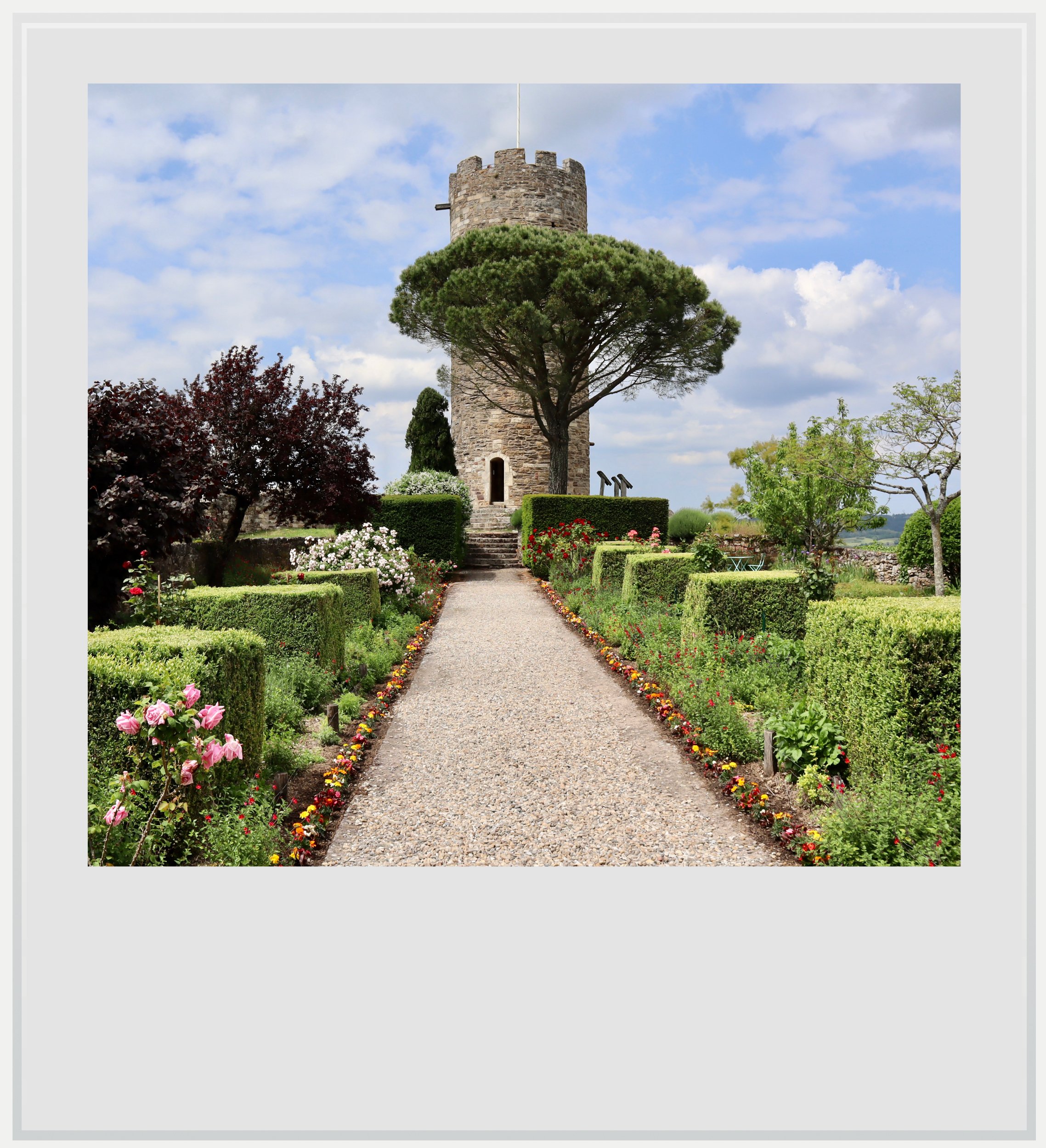
Instead of walking up straight to the castle, I chose the long way and walked around Turenne for a few hours, on a marked path that took me down to the valley of the Tourmente river, hiking along the rail track linking Brive and Aurillac, that gives this entry its theme. I climbed up towards the castle from the back, through fields and dirty trails, but the result was incredible: the castle, invisible throughout my walk, suddenly came up right in front of me. I walked up a few steps and enjoyed the view at the top of the Cesar tower before going down slowly through narrow streets which were unexpectedly not crowded.
In keeping with my pledge, I walked to Turenne’s rail station and took a fifteen-minute train ride back to Brive.
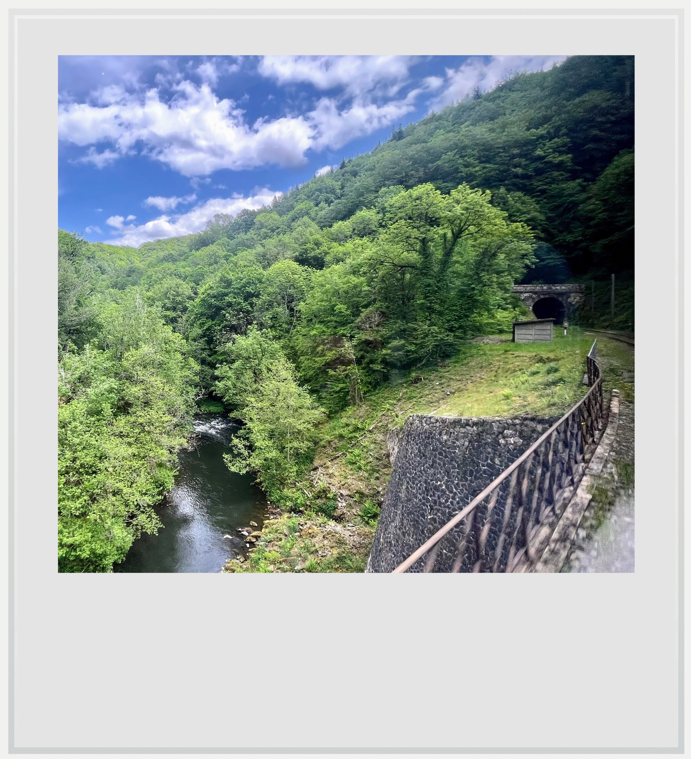
The next morning, I made my way back to the station to take a regional service to Aurillac. As I rode the small X73500 set, I passed by Turenne and then close to Collonges. The track is shared with services going south to Figeac (where I would stop later) and Toulouse until Saint-Denis-près-Martel. After a few miles on a semi-flat plateau, the track enters into its most magical portion: the Cère river gorge.
This was a point in the trip where the landscape changed dramatically. The track shares just a little bit of the valley with the river itself, passing through tunnel after tunnel while staying dangerously close to the river on the left, and the cliffs on the right. No road goes through the gorges and it felt a bit eerie, as if no one else in the world was allowed to enjoy this.
It felt a bit eerie, as if no one else in the world was allowed to enjoy this.
The track isn’t maintained as it should be, because passenger traffic between Brive and Aurillac is not enough for services to break even, so we had to endure speed limits of twenty miles per hour for a bit of the trip. While it may not be an issue for tourists, it adds about fifteen minutes to a trip that already takes longer than driving, and it certainly doesn’t help the train be an alternative for anyone but the unmotorized. Because people have realized the line closure is a real threat, there is now movement to find funding and secure its future. I really hope it happens, so that crossing the Cère river gorge stays as magical as it is today.
I arrived in Aurillac almost two hours after leaving Brive, and the altitude change took me by surprise. It was significantly colder there, and I could have used another sweater or two. I walked to my hotel and after dropping my bag, set up to discover the town.
Photos from top to bottom: Collonges-la-Rouge from nearby fields, place Charles-de-Gaulle in Brive-la-Gaillarde, rue de l’Hôtel de Ville in Brive-la-Gaillarde, Brive’s city hall from place Saint-Pierre, route du Friac in Collonges-la-Rouge, rue de la Barrière in Collonges-la-Rouge, a TER train service between Brive and Aurillac near Turenne, the village of Turenne as seen from county road D8, the Turenne castle gardens with the Cesar tower and a view from the Cère river gorge aboard a Brive to Aurillac train service.
All photos are mine and are copyrighted.